

In the highlands of western Mexico, April and May are, without a doubt, the hottest months of the entire year.
Because those who live here normally enjoy one of the best climates planet Earth has to offer, few people bother to install air conditioning in their homes, opting instead to aguantar or suffer patiently until the last day of May, knowing that in June the ancient god of water, Tlaloc, will surely bring the first showers of the rainy season, immediately cooling the air and restoring those perfect temperatures to which they are accustomed.
Meanwhile, whenever the opportunity arises, the people of western Mexico, especially those who live in Guadalajara, escape the heat by heading either to the beach or to the mountains. Here, let’s take a look at their favorite choice of mountain towns, Tapalpa.
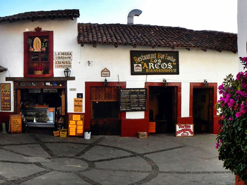
Tapalpa is located 90 kilometers southwest of Guadalajara and its elevation is about 2,000 meters above sea level. Because it is well over a mile high, it has a cool climate and because it’s a Pueblo Mágico it also has a cool look: steep and narrow cobblestone streets, whitewashed buildings with red-tile roofs, and picturesque wooden balconies.
Visiting Tapalpa means strolling through these little streets without a care in the world, deeply breathing the cool, crisp, clean air and thus awakening an appetite for the pueblo’s most famous dish, borrego al pastor: lamb marinated in spices and grilled on a spike, “shepherd style.”
When night falls, you can relax in front of a crackling fireplace with a flavorful ponche de granada, grenadine punch made with tequila or mezcal, eventually collapsing into bed and sleeping like a lion.
In the early 1500s, the Spaniards arrived in this area and found an indigenous settlement “about three leagues” from the present-day location of Tapalpa. These people, called Atlaccos, put up no resistance to the conquerors, who started a colony between 1531 and 1532.

It was, however, only in 1825 that the population was big enough to be called a pueblo. Even today there are only about 5,500 people living in the town which, by the way, was declared a Pueblo Mágico in 2011.
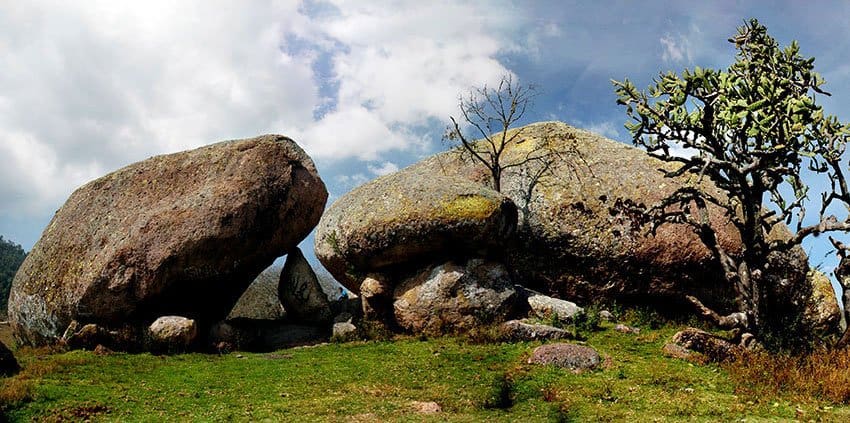
Only a 15-minute drive north of Tapalpa lie Las Piedrotas, the “Great Big Rocks,” huddled in clusters like enormous dinosaur eggs in a wide meadow with no other such rocks in sight. A barbed-wire fence forces visitors to park on the roadside and pass through a caracol — the rural equivalent of a turnstyle — to wander about among those massive monoliths.
Well, to tell you the truth, those Piedrotas are actually mere pebbles in comparison with another rock called La Piedra Gorda, The Fat Rock, a monolith located only four kilometers from town, but a bit difficult to reach, although the view from its peak is well worth the effort.
The last time I visited the Piedra Gorda was with friends who planned to install a bolt in the rock to which visitors could attach a safety line while peering over the edge of a sheer drop of some 50 meters.
We drove northwest out of Tapalpa to the DIF (Family Development Center) and parked. Here the altitude is about 2,090 meters above sea level. We crossed a stream by leaping from rock to rock and then walked along a rough brecha (dirt road) which is closed to vehicles (except those of people living in the area).
Eventually we crossed a charming meadow filled with wildflowers. Since Tapalpa has a strange tradition in which people throw Santa María flowers at one another on Mexican Independence Day, we waged a few battles of our own before continuing uphill to La Piedra Gorda, which is nestled among a few smaller rocks.
There’s a sort of ladder here to help you get up to the top of the rock where you suddenly come upon a magnificent, eye-popping view. It’s Mother Nature making IMAX look like a postage stamp, from an altitude of about 2,400 meters above sea level (7,874 feet).
This hike is 4.5 kilometers one way and took us about 90 minutes, strolling along at a leisurely pace.
Anyone who visits Tapalpa will soon hear about “a wonderful waterfall over 100 meters high.”
This is El Salto del Nogal, the Walnut Cascade, and it is most certainly worth visiting if you are in good physical condition.
[soliloquy id="77274"]
The drive from Tapalpa takes just a little over half an hour and the hike down to the waterfall about the same amount of time. Just how long you will need to get back up, of course, depends on what kind of shape you are in.
The trail takes you across a bubbling brook, through several stone walls and then you are on your way down, down, down into a deep canyon.
At a certain point you’ll see some shallow shelter caves in the cliff to your left. This spot, I am told, is called The Convent and they say several Cristeros hid there during the Cristero War (1926–29) when the Mexican government tried to eliminate the power of the Catholic Church.
During most of your descent you’ll hear the roar of the mighty waterfall but you won’t be able to see it until you reach the very bottom, where there is a large pool of water dotted with huge boulders and dwarfed by the majestic foaming white ribbon linking the pool to a patch of blue sky far above.
Unfortunately, the icy water temperature plus a powerful wind generated by the falls make it difficult to swim in this pool but there is a smaller, windless waterfall with its own “perfect pool” for swimming just a little further downstream.
To reach the trail to the waterfall, ask Google Maps to take you to “Cascada el Salto del Nogal, Tapalpa.”
What else is there to do in the vicinity of this magical town?
Actually, there is so much that I plan to continue this description next week, so if you are thinking of visiting the Sierra de Tapalpa, you’d better allow several days, so you can have a good look around.
The writer has lived near Guadalajara, Jalisco, for more than 30 years and is the author of A Guide to West Mexico’s Guachimontones and Surrounding Area and co-author of Outdoors in Western Mexico. More of his writing can be found on his website.