

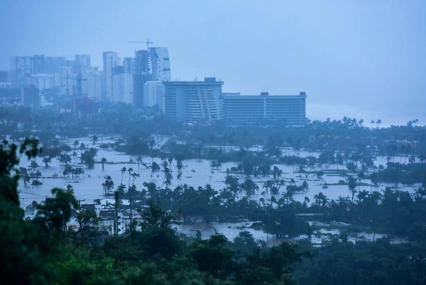
As residents of Mexico’s Pacific coast area reel from the effects of Tropical Storm John, today’s weather forecast suggests there is little relief in sight.
In its Monday morning weather bulletin, Mexico’s national weather agency (SMN) reported that intense rains are forecast to continue in Guerrero, Chiapas and Oaxaca.
Se pronostican #Lluvias intensas en regiones de #Guerrero, #Oaxaca, #Chiapas, #Tabasco, #Veracruz, #Yucatán y #QuintanaRoo.
Ve el #Pronóstico completo de lluvias ⬇️ pic.twitter.com/RIBVZGGRKc
— CONAGUA Clima (@conagua_clima) September 30, 2024
These three storm-battered states could see an additional 75-150 millimeters of rain on Monday. Guerrero is especially vulnerable to flooding and landslides after John dumped rain on its coastal mountain region for the better part of last week, leaving at least 23 dead across the state.

Farther north along the Pacific coast, Colima, Jalisco and Michoacán are projected to see 50-75 mm of rainfall.
According to the weather agency Meteored, unstable tropical systems featuring tropical waves, monsoon troughs and tropical cyclones threaten to bring torrential rains across Mexico this week.
As a result, areas including southern Guerrero and coastal Oaxaca, as well as the Isthmus of Tehuantepec extending to the Gulf, could see considerably more rain today and throughout the week. The SMN alerted the public to be on the lookout for mudslides and flash flooding, especially where the ground has already been saturated with rain.
The SMN reported at 6 a.m. on Monday that there are currently two low-pressure areas in the Pacific that could develop into tropical cyclones.
The first, off the coast of the states of Oaxaca and Guerrero, has a 20% chance of becoming a tropical cyclone in 48 hours but a 70% chance of becoming a storm in the next seven days. The SMN said this system is located roughly 200 kilometers south-southwest from Punta Maldonado, Guerrero, the spot where Hurricane John came ashore exactly one week ago.
The second system is located about 160 kilometers offshore from Pijijiapan, Chiapas, and has just a 20% chance of becoming a cyclone in the next week. The fourth cold front of the season is forecast to arrive by the weekend, contributing to the inclement conditions in Mexico’s storm-affected regions.
Across the country on the Gulf coast, Tabasco and Veracruz will see 75-150 mm of rain, while Campeche, Quintana Roo, Puebla and Yucatán are projected to get 50-75 mm of precipitation.
The Central American Gyre (CAG) is the main contributor to the weather conditions in Mexico’s southeast and along the eastern Gulf of Mexico. An early and late-season source of tropical development, the CAG can bring dangerous levels of rainfall in a very short period.
Meteored says the CAG will primarily affect the weather across the Yucatán Peninsula and up into the Gulf of Tehuantepec this week.
With reports from Meteored, MVS Noticias and Infobae