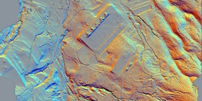
Researchers now have a fuller picture about the size of an ancient Purépecha city in Michoacán after using laser technology to detect structures hidden under vegetation and the ground.
Known structures at the Tzintzuntzan site near Lake Pátzcuaro numbered in the dozens before National Institute of Anthropology and History (INAH) researchers detected more than 1,000 using the laser surveying method known as LiDAR (light detection and ranging).
“To date, we have identified more than 1,000 archaeological elements in an area of 1,075 hectares,” INAH researcher José Luis Punzo Díaz said earlier this year.
“We went from knowing of a few dozen monuments to more than a thousand in these first kilometers we’ve explored,” said the head of the LiDAR project, which began in 2021 and is supported by the United States-based National Center for Airborne Laser Mapping and NASA.
LiDAR technology, satellite images and digital mapping models have together given researchers “a more complete image of this ancient city” Punzo said, explaining that the site – whose name means “place of the hummingbirds” in Purépecha – has been the subject of archaeological study by INAH for 90 years.
Among the structures detected at Tzintzuntzan – the capital of the vast Purépecha, or Tarasco, empire – via LiDAR are pyramids, terraces, platforms and residential dwellings, INAH said in a statement.
They are located “on the lower slopes of hills and near Lake Pátzcuaro, and not just in the area near the ritual zone as had been represented on site maps.”
Additional LiDAR surveys are expected to detect even more structures at Tzintzuntzan, located in the municipality of the same name.
“This project is going to be very important,” Punzo told the newspaper El Universal earlier this month.
“I can say that [what we’ve found so far] is the tip of the iceberg. … LiDAR is the base to study the city in the coming decades. We knew almost nothing about Tzintzuntzan apart from its central area,” he said.
LiDAR uses lasers to map areas, from the air or from handheld devices. The technology emits brief light pulses whose reflection allows researchers to create a 3-D map with GPS and computers of objects that might otherwise be invisible to the naked eye.
Laser technology has also been used to detect almost 500 Mesoamerican ceremonial centers in southern states and two pre-Hispanic settlements buried beneath a third ancient city in Michoacán, among other discoveries.
With reports from El Universal
