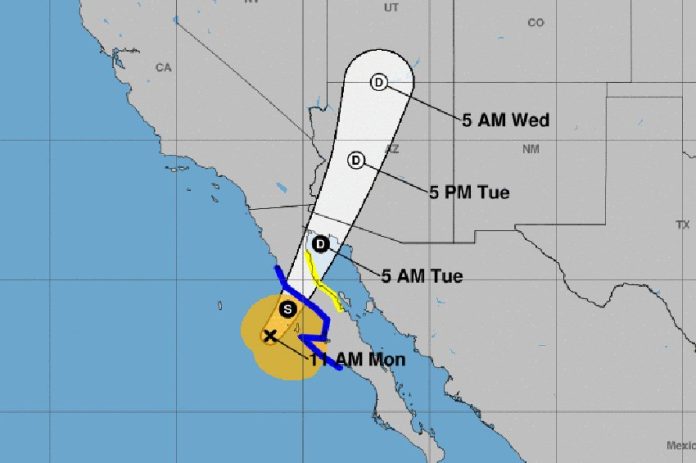
Tropical storm Rosa was located off the Pacific coast of Baja California this morning and is forecast to make landfall later this evening, bringing heavy rain, strong winds and potentially life-threatening flash floods.
The National Meteorological Service (SMN) said in a statement that Rosa, which had earlier strengthened to a category 4 hurricane, was located 150 kilometers southwest of Punta Eugenia, Baja California Sur, at 9:00am CDT.
The storm is forecast to reach land late this evening between Punta Eugenia and San Quintín, Baja California, before moving across the peninsula and into the northern Gulf of California later tonight.
The SMN said the tropical storm had maximum sustained winds of 75 kilometers per hour and gusts exceeding 95. It is moving at 19 kilometers per hour to the north-northeast.
Intense storm activity is forecast for Mexicali and Ensenada in Baja California and San Luis Río Colorado, Puerto Peñasco, Caborca and Plutarco Elías Calles in Sonora.
The United States National Hurricane Center (CNH) is forecasting 7.5 to 15 centimeters of rain for Baja California and northwestern Sonora with isolated falls of up to 25 centimeters.
Very strong storms are forecast for parts of Chihuahua and Sinaloa while strong storms are predicted in Baja California Sur, the SMN said.
Swells of three to five meters with dangerous currents are predicted for the coasts of both Baja California and Sonora.
A tropical storm warning is in effect for the west coast of the Baja California peninsula from Punta Abreojos to Cabo San Quintín and for the east coast from Bahía de los Ángeles to San Felipe.
Another tropical storm, just below hurricane strength, was located in the Pacific Ocean 1,000 kilometers southwest of Manzanillo, Colima, at 9:00am CDT, the SMN said.
Tropical storm Sergio had maximum sustained winds of 110 kilometers per hour with gusts exceeding 140 kilometers per hour.
However, Sergio poses no immediate threat to land as it is moving west away from the Mexican coast at 22 kilometers per hour.
The SMN is still forecasting that it will bring rain to western Mexico and swells of one to three meters to the coasts of Colima, Jalisco and Michoacán.
It also warned of possible landslides, overflowing rivers, flooding and road blockages.
Source: El Financiero (sp)
