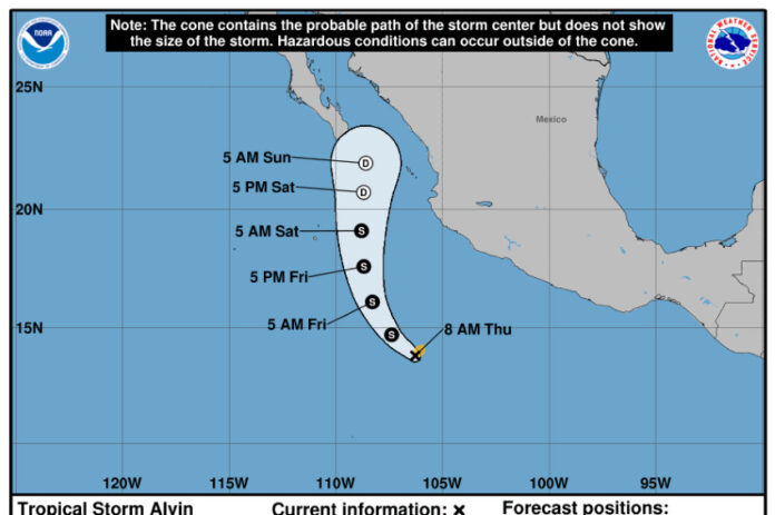
Tropical Storm Alvin became the Northern Hemisphere’s first named storm of the year on Thursday after it formed in the eastern Pacific Ocean, off the coast of the Mexican state of Michoacán state.
Alvin formed at 9 a.m. almost 600 km off the coast of Punta San Telmo in Michoacán. At the time, it was moving northwest at a speed of 17 km/h with maximum sustained winds of 65 km/h, according to Mexico’s National Meteorological Service (SMN).
The United States National Hurricane Center reported that the storm is likely to bring heavy rain and strong winds to Mexico’s west-central coastline through the weekend.
Alvin is the first registered tropical storm in the Northern Hemisphere this year, bringing an end to several months without strong activity. Typically, multiple storms have formed in the region by this time in the year.
A typical hurricane season in the eastern Pacific sees 15 named storms. However, the National Oceanic and Atmospheric Administration predicts a below-average eastern Pacific hurricane season, while it forecasts an above-average hurricane season in the Atlantic Ocean.
Alvin may potentially strengthen into a hurricane, according to the weather forecaster AccuWeather. However, it is expected to lose wind intensity as it moves over cooler waters and an area of increased wind shear, which typically weaken storms, as it moves toward northern Mexico over the weekend.
.@NOAA‘s #GOESWest 🛰️ was watching as #Alvin, the first tropical storm of the eastern Pacific hurricane season, formed this morning. #GOES18
Get the latest updates: https://t.co/Pu1fZWigQ4 pic.twitter.com/lKmlqQqTv3
— NOAA Satellites (@NOAASatellites) May 29, 2025
“While many eastern Pacific tropical storms and hurricanes move west-northwest and eventually fizzle in the open ocean, some do strike land, as we saw in 2023 with the remnant of Hurricane Hilary in the Desert Southwest and with Category 5 Hurricane Otis in Acapulco, Mexico,” meteorologist Sara Tonks stated in an online forecast on Thursday.
Hurricane Otis was the strongest ever to hit Mexico’s Pacific coast and Acapulco is still recovering from the widespread damage caused by the event, as well as from Hurricane John which slowed the city’s recovery when it hit in September 2024.
Weather warnings
Alvin is forecast to progress along the following trajectory:
- 6 p.m. May 29: 580 km southwest of Punta San Telmo, Michoacán, as a tropical storm
- 6 a.m. May 30: 510 km southwest of Playa Pérula, Jalisco, as a tropical storm
- 6 p.m. May 30: 436 km west-southwest of Playa Pérula, Jalisco, as a tropical storm
- 6 a.m. May 31: 360 km west-southwest of Cabo Corrientes, Jalisco, as a tropical storm
- 6 p.m. May 31: 270 km south-southeast of Cabo San Lucas, Baja California Sur, as a remnant low
- 6 a.m. June 1: 170 km southeast of Cabo San Lucas, Baja California Sur, as a remnant low
Mexico’s SMN expects Alvin to cause heavy rains and strong winds in Mexico’s western, central and southern states over the coming days, which could cause river and stream levels to rise, as well as landslides and flooding in low-lying areas.
There are rainfall alerts for 12 states, including Mexico City, Michoacán, Guerrero, Puebla, Jalisco, Colima and Guanajuato. Very heavy rain is expected in Querétaro, Hidalgo, Tlaxcala, México State and Morelos.
Meanwhile in the Atlantic, SMN announced on Thursday that it is monitoring a tropical depression in Veracruz that could become the Atlantic’s first named storm of the season. The cyclone is expected to bring rainfall to the Gulf Coast state.
With reports from USA Today, Imagen de Veracruz, N+ and The Weather Channel
