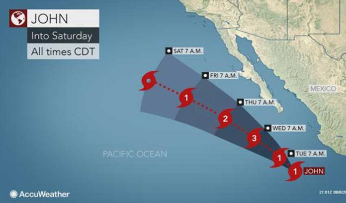
Some windy and wet weather is forecast for parts of six states due to a tropical storm and a hurricane in the eastern north Pacific Ocean. But neither is forecast to make landfall.
Most of the adverse weather will be caused by Tropical Storm Ileana, but the United States National Hurricane Center forecast today that it would likely dissipate by late Tuesday due to the influence of Hurricane John to its southwest.
As of 4:00pm CDT, Ileana was situated about 245 kilometers south-southeast of Manzanillo, Colima, and generating sustained winds of 100 kilometers per hour.
A tropical storm warning is in effect for Tecpan de Galeana, Guerrero, to Cabo Corrientes, Jalisco.
The National Meteorological System forecasts intense storms in areas of Colima, Michoacán, Guerrero, Puebla, Veracruz and Oaxaca. Winds will gust to 60 kilometers an hour in Guerrero and Oaxaca, where two to four-meter waves can be expected.
The National Hurricane Center (NHC) said there were no coastal watches or warnings in effect due to Hurricane John, but suggested that its progress should be monitored by residents of the southern portion of the Baja peninsula.
As of 4:00pm CDT, John was about 515 kilometers southwest of Manzanillo and 790 kilometers south-southeast of the southern tip of Baja.
Winds were 120 kilometers per hour and the storm was moving northwest at 13 kilometers an hour. The NHC said it will strengthen and should become a major hurricane by late tomorrow.
It will produce large swells that will affect the coasts of southwestern Mexico and the southern portion of the Baja peninsula.
Mexico News Daily
