Tropical Storm Ileana formed in the Pacific Ocean on Thursday afternoon and is expected to produce intense rains along the northwestern coast of Mexico throughout the weekend.
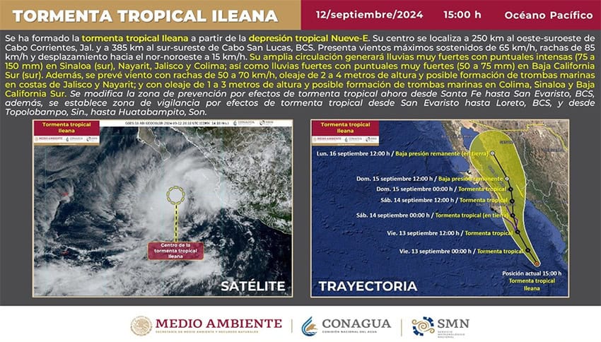
The National Meteorological Service (SMN) reported that as of 2 p.m., the tropical storm — moving north-northwest at 15 kph — was located 250 km east-southeast of Cabo Corrientes, Jalisco, and 385 km south-southeast of Cabo San Lucas, Baja California Sur.
#AvisoMeteorológico Se formó la #TormentaTropical #Ileana en el océano #Pacífico, a partir de la #DepresiónTropical Nueve-E.
Todos los detalles en ⬇️https://t.co/t3AEq7WQNz pic.twitter.com/cTFwac7C86
— CONAGUA Clima (@conagua_clima) September 12, 2024
In its Thursday afternoon bulletin, the SMN reported that it had issued tropical storm warnings in coordination with the U.S. National Hurricane Center (NHC) and called on residents of Baja California Sur, Sinaloa and Sonora to closely monitor the storm’s progress. Ileana is expected to hit the Baja peninsula Friday before crossing the Gulf of California toward mainland Mexico.

A Tropical Storm Warning (conditions are expected somewhere within the warning area within 36 hours) is in effect for:
- West coast of Baja California Sur from Santa Fe southward
- East coast of Baja California Sur from San Evaristo southward.
At the same time, a Tropical Storm Watch (conditions are possible within the watch area, generally within 48 hours) is in effect for:
- Baja California Sur north of San Evaristo to Loreto
- From Topolobampo, Sinaloa, to Huatabampito, Sonora.
According to the SMN, Tropical Storm Ileana is expected to produce 75-150 mm of rain in Colima, Jalisco, Nayarit and southern Sinaloa and 50-75 mm in southern Baja California Sur.
Weather agency Meteored forecast electrical storms and hail storms for the affected areas, while also cautioning about the potential for waterspouts. Residents are warned to be on the lookout for flash flooding and mudslides.
High winds associated with tropical storm conditions are expected to first reach the southern Baja California peninsula within the warning area by early Friday and persist through early Saturday.
Swells generated by Tropical Storm Ileana will affect portions of the coast of west-central Mexico during the next day or so, and will spread northward along the coasts of the southern Baja California peninsula and mainland Mexico beginning Thursday night. These swells are likely to cause life-threatening surf and rip current conditions.
Low atmospheric pressure across the north, northeast and central regions of Mexico will be impacted by the moisture coming in from the Pacific, generating electrical storms and heavy rains that will extend to southeastern Mexico, according to Meteored.
Meanwhile, flood waters have mostly subsided in Matamoros, Tamaulipas, after Hurricane Francine drenched the border state on Tuesday and Wednesday as it made its way north.
With reports from Milenio, The Port Arthur News and Meteored