

“This is the year we get hit by a major hurricane.” No one has said it in exactly those words. But I’ve heard the sentiment echoed in various ways by friends about Baja California Sur’s 2026 hurricane season (May 15 to Nov. 30 for the Eastern Pacific).
As for the reasoning, it’s based largely on two things: the idea that we’re overdue — the region hasn’t experienced a catastrophic hurricane since Odile in 2014 — and the fear of a “Super El Niño,” which it appears there’s a good chance the current El Niño climate pattern may intensify into by November or December, potentially extending hurricane season beyond its official end date.
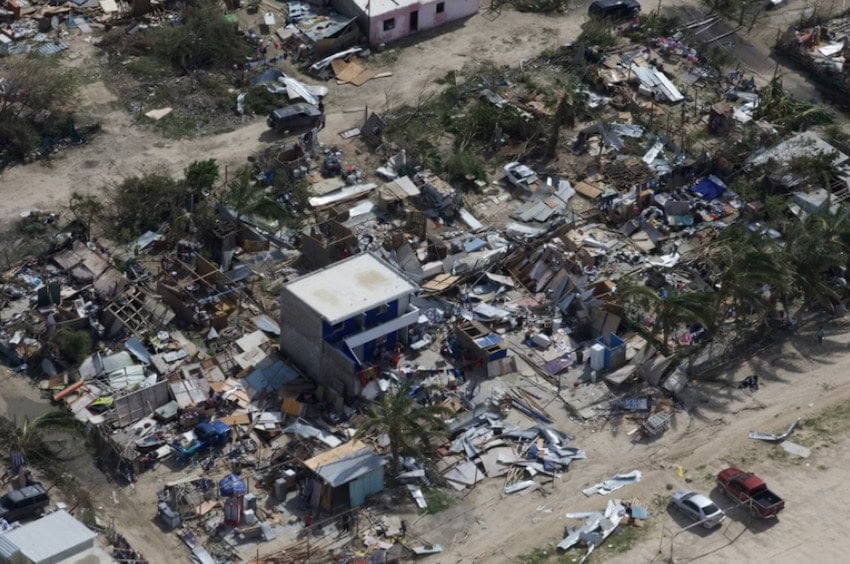
The “overdue” argument has no basis in scientific fact, of course. However, there is anecdotal evidence that suggests there is one major storm per decade that seems particularly destructive, and that lives on in the memories of regional residents: Liza in 1976 (the deadliest storm in the state’s history), Paul in 1982, Fausto in 1996, Juliette in 2001 and Odile in 2014, bringer of over one billion dollars in property damage, being the emblematic examples from the last 50 years.
The Super El Niño, on the other hand — meaning simply a very strong El Niño with water temperatures 2 degrees Celsius or more above average — is a very real and very scary possibility.
What could a Super El Niño mean for Baja California Sur’s 2026 hurricane season?
Hurricanes can’t occur until ocean water hits a certain temperature: 26.5 degrees Celsius, or 80 degrees Fahrenheit. The warmer the water gets, beyond that point, the more likely hurricanes are to develop, the stronger and longer lasting they’ll be and the more prone to rapid intensification. So, supercharging temperatures by an additional 2 degrees Celsius (3.6 degrees Fahrenheit), the definition for a Super El Niño, on top of an already record-hot, human-warmed climate, is a recipe for disasters.
El Niño itself is simply the warming range of the El Niño-Southern Oscillation climate pattern (ENSO), as opposed to the cooling of surface temperatures associated with La Niña. As of June 11, per the National Oceanic and Atmospheric Administration (NOAA), the Pacific Ocean has entered the El Niño phase, with a certainty it remains at that level through the end of hurricane season and a 63% chance that it reaches the “very strong” threshold for the so-called Super El Niño phenomenon. If it happens, it would only be the fourth time in the last 50 years: following the 2015-16, 1997-98 and 1982-83 occurrences.
The ocean has never been hotter
In each of those cases, Super El Niños were associated with suppressed hurricane activity in the Atlantic Ocean, but strongly enhanced storm activity in the Pacific. However, in none of those years were the water temperatures as hot as they are now. That’s because, as the Institute of Atmospheric Physics at the Chinese Academy of Sciences noted last year, “The ocean is the hottest it has ever been recorded by humans, not only at the surface temperature but also for the upper 2,000 meters.”

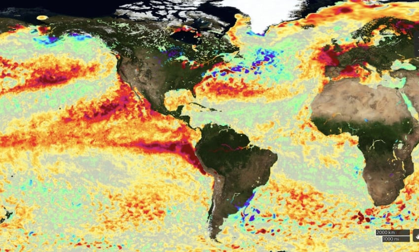
So a Super El Niño this year would take us into uncharted territory, with Pacific Ocean sea surface temperature raised beyond known limits.
Projections for the 2026 season
Whether or not Super El Niño conditions arise as expected, the Eastern Pacific region will almost certainly see above-normal storm activity during Baja California Sur 2026’s hurricane season due to the warmer water temperatures. NOAA is predicting 15–22 named storms for the 2026 season, 9-14 of which will be hurricanes and 5-9 will be major hurricanes (Category 3 or higher, with maximum winds above 111 miles per hour), a notably high number.
Mexico’s National Meteorological Service, meanwhile, was more conservative in its predictions: 18-21 named storms and 5-6 hurricanes, of which only 4-5 will be major ones.
Hurricane preparedness in Baja California Sur
Predicting the future is a notoriously difficult business, even for weather agencies. So in Baja California Sur — where hurricanes are historically much more likely than in the state of Baja California — preparedness is the watchword.
“We must not be negligent,” warned BCS Governor Victor Castro, per El Sudcaliforniano. “It is essential that people living in high-risk areas heed the recommendations and not remain in their homes in case of an emergency, because that is where the greatest tragedies stem from. It cannot be due to complacency or carelessness.”
The governor’s recommendation to residents was the creation of an emergency backpack, the contents of which include at least three days’ worth of water and non-perishable food, waterproof protection for important documents, flashlights and batteries, plus hygienic items and a first aid kit.
Readiness in La Paz and Los Cabos
Operational plans are also in place for the municipalities of La Paz and Los Cabos, with the former having already designated 32 temporary shelters — eight in urban areas, 24 for rural communities — in case of hurricanes or other powerful storms, with these shelters capable of accommodating up to 2,450 people. Additionally, a dozen specialized response brigades will be on call for search and rescue, with a Safe Crossings Operation in effect for 27 locations considered at high risk for water runoff.
Similar preparations have been made in Los Cabos, where 40 temporary shelters have been readied (some hotels have also been certified as shelters, if needed), and 13 specialized brigades sworn in for emergency use in rescues and evacuations. The municipality’s civil protection authorities also attended April meetings in Veracruz as part of a national effort to develop better preventative strategies and response protocols.
Chris Sands is a writer and editor for Mexico News Daily, and the former Cabo San Lucas local expert for the USA Today travel website 10 Best and writer of Fodor’s Los Cabos travel guidebook. He has also contributed to numerous other websites and publications, including The San Diego Union-Tribune, Marriott Bonvoy Traveler, Forbes Travel Guide, Porthole Cruise and Travel, and Cabo Living.