

Many years ago a friend spoke to me of the Great Rocks of Quila: “They are simply a climber’s dream,” he said. “Too bad they are located in the middle of nowhere,” he added, “but then again, what a gorgeous place for camping . . . just the sort of place you would love, John!”
I was hooked, of course, and started studying the best way to get to the Sierra de Quila, located about 75 kilometers southwest of Guadalajara.
Then, still not sure how to get there, off we went over dusty dirt roads, asking for directions at every farm house and backtracking frequently. Finally we ended up camped on a bluff overlooking a vast forest dotted with several truly impressive rock formations with sheer faces 100 meters high, a rock climber’s dream indeed.
During our stay, we hiked through the pine forest to several of the monoliths and along the way, discovered spectacular multicolored meadows bursting with thousands of wildflowers. We also came upon what I considered a very ordinary-looking turtle, but when I published a photo of it years later on the internet, it raised a great deal of excitement.
“That was a Terrapene nelsoni, a spotted box turtle, John! They are extremely rare and you were very lucky to see one. I want to organize a hunt to find out if there are any more left in the Sierra de Quila.”
Fortunately, over the passing of years, the Sierra de Quila had been declared a protected area and reasonably drivable roads had been built offering access to it. Today there are signs showing you where to go, several designated camping areas and even a few rangers to make sure visitors follow the rules.
Not long ago, I revisited the Quila reserve, this time quite easily, driving from Guadalajara to the little town of Tecolotlán, which means Place of the Owls. From here a long and winding road takes you north into the park. Even before leaving Tecolotlán we learned all about Quila’s attractions at the park’s little office in town.

“There are 11 waterfalls in Quila,” we were told, “the most spectacular being the gorgeous Cascada de Santa Rosa, with a vertical difference of 470 meters from top to bottom. And then we have mountain peaks like El Huehuentón (2,565 meters high). As for animals, we have jaguars, peccaries, pumas, jaguarundis, white-tailed deer, skunks, coatis and squirrels plus another 285 species of animals, but we are especially proud of our axolotls, which are famous for their ability to regenerate lost limbs.”
Soon we were out in the forest, wandering among gorgeous, delicate Lumholtz’s pines (Pinus lumholtzii), visiting several of the magnificent waterfalls and exploring the extensive ruins of La Máquina, a water-powered sawmill which must have been truly impressive in the days before electricity was available. It soon became obvious to us that every inch of this forest is dramatically beautiful and refreshing to walk or drive through.
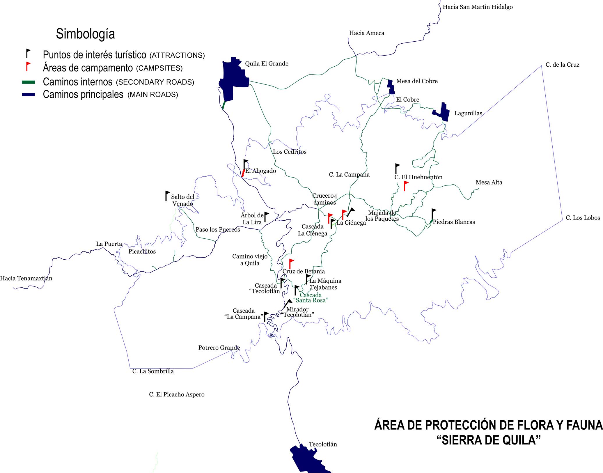
The protected area covers over 15,000 hectares, but it has many roads and you can find your way around easily using a map available here. The park has four designated campsites featuring running water as well as clean and working toilets.
One of the camping areas, called La Ciénega, also has an interesting little museum. Here, serenaded by a Mexican whip-poor-will, I spent a night under the stars with friends who promised to guide me to nearby Huehuentón Peak via a trail through the woods.
The next morning, we started our hike by crossing a bridge over a small stream behind the museum. We walked along on a thick, soft carpet of pine needles through which the first tiny wildflowers of the rainy season were poking their heads. At two points we intersected with a dirt road by which you can get close to Huehuentón Peak by car, without the exercise.
However, you’d also miss fascinating creatures we spotted along the way, such as a mother scorpion carrying her babies on her back and a “National Congress of Ladybugs” all meeting on one plant — not to mention the breathtakingly beautiful forest.
Part of our breath, of course, was taken by the rise in altitude from 2,146 meters to 2,565 meters. Nevertheless, having loped along at an easy pace, we covered the distance from La Ciénega to the peak in two hours.
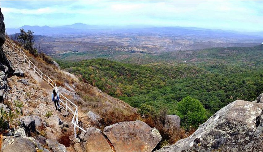
The last part of the route is up rustic steps to a gap between two tall rocks where our leader shouted to us: “Better put on your coats before you get up here — it’s freezing!”
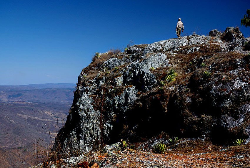
It was hard to believe, but true. On the other side of the gap, the wind was howling and the view was overwhelming. A short scramble with a guide rail for protection got us up to the top of a narrow pinnacle where there is barely room for a repeater antenna and a tiny one-room house where a ranger keeps watch for forest fires 24 hours a day.
During our brief visit, however, it was a movie he was watching! Fortunately, we saw no smoke on the horizon that day, only a 360-degree view of one of the most beautiful forests you could ever imagine.
If you would like to visit the Sierra de Quila Nature Reserve, the drive should take a bit less than three hours either from Guadalajara or the Lake Chapala area. Because some roads leading to the park are unusually steep, I recommend that you go there via the town of Tecolotlán.
Just ask Google maps to take you to “La Cienega, Sierra de Quila,” where you’ll find the park headquarters, museum and a great camping area, with Huehuentón Peak only 2.6 kilometers to the northeast as the crow flies.
By the way, on your way to La Ciénega from Tecolotlán you’ll pass the impressive Cascada de Santa Rosa. Have a great trip!
[soliloquy id="80757"]
The writer has lived near Guadalajara, Jalisco, for more than 30 years and is the author of A Guide to West Mexico’s Guachimontones and Surrounding Area and co-author of Outdoors in Western Mexico. More of his writing can be found on his website.


