Thursday, May 29, 2025

Coronavirus stoplight map takes on softer hues as the latest wave continues its decline

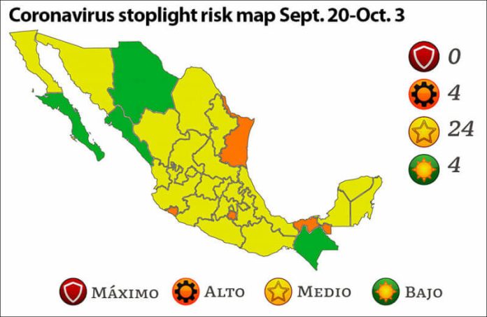
The declining third wave of COVID-19 is reflected in the new coronavirus stoplight risk map, issued Friday by the federal Ministry of Health.

More low-risk green and a lot more medium-risk yellow color the new map that takes effect on Monday. 

Baja California Sur and Sinaloa will be painted green, joining Chihuahua and Chiapas, while 24 states will be yellow, nine more than on the map issued two weeks ago.

At high risk and colored orange are four states, down from 13. No states are at maximum risk red.

Yellow states are:

  • Aguascalientes
  • Baja California
  • Campeche
  • Coahuila
  • Durango
  • Guanajuato
  • Guerrero
  • Hidalgo
  • Jalisco
  • Mexico City
  • México state
  • Michoacán
  • Nayarit
  • Nuevo León
  • Oaxaca
  • Puebla
  • Querétaro
  • Quintana Roo
  • San Luis Potosí
  • Sonora
  • Tlaxcala
  • Veracruz
  • Yucatán
  • Zacatecas

Painted orange on the new map are:

  • Colima
  • Morelos
  • Tabasco
  • Tamaulipas

Mexico News Daily

Have something to say? Paid Subscribers get all access to make & read comments.
Angry Trump

US trade court blocks Trump’s ‘fentanyl trafficking’ tariffs against Mexico

0
Tariffs remain in place, for now, after the Trump administration quickly appealed the ruling.
A map showing the path Tropical Storm Alvin is predicted to take, starting off the Mexican coast and approaching the Baja Peninsula

Tropical Storm Alvin forms off Pacific coast, heading for Baja

0
The first named storm of Pacific hurricane season is expected to bring wind, rain and heavy swell to coastal states from Michoacán up to Baja California Sur.
Firefighters battle a forest fire in Sinaloa.

Sinaloa steps up the fight against wildfires and prays for rain

0
Severe drought and security threats are complicating efforts to control fires in Concordia, Badiraguato and other areas of the state.