

Drought conditions eased in August as much-needed rain fell across much of Mexico, but the precipitation caused another problem in some parts of the country: flooding.
Just over 27% of Mexico’s territory was experiencing some level of drought at the end of August, according to the National Water Commission (Conagua). While the figure remains high, it’s 14 points lower than that recorded at the end of July, when 41% of the nation’s territory was in moderate, severe, extreme or exceptional drought.
In its latest drought monitor report, Conagua reported that 596 municipalities were in drought at the end of last month, while an additional 975 were “abnormally dry.”
The former figure declined 22.5% in the space of a month after July ended with 770 municipalities in drought. There are currently no municipalities in exceptional drought – the worst category, a situation that hadn’t been reported since the second half of February.
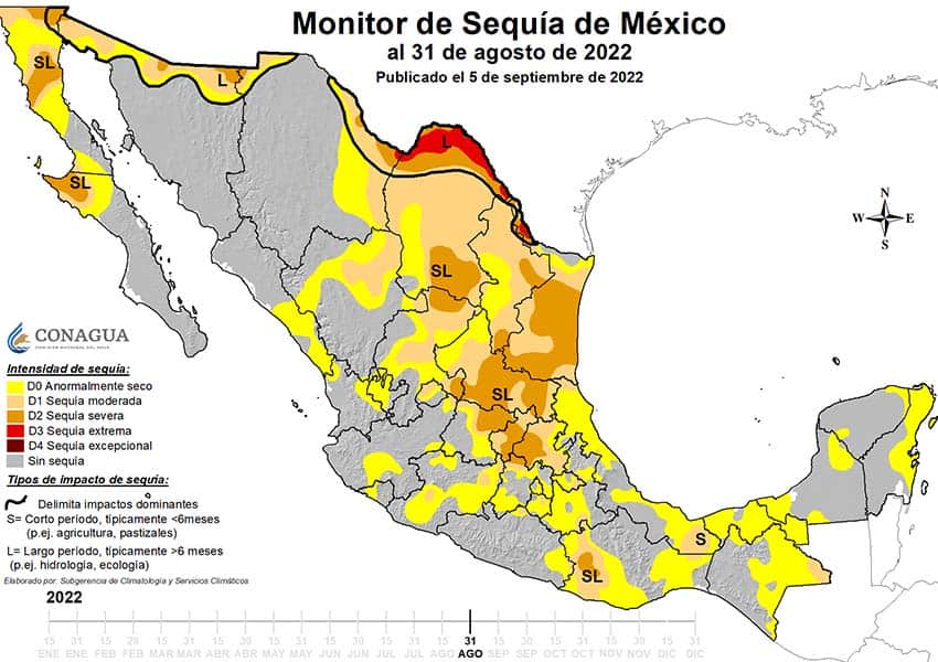
Conagua said that rainfall was above average in the second half of August in the northwestern, northern, central-west and southern regions of the country as well as the Yucatán Peninsula. It said that the rains were brought by the North American monsoon, which “interacted with an unseasonal cold front” in the second half of last month.
Conagua said that rainfall eased drought conditions on the Baja California peninsula and in the states of Sonora, Durango, Chihuahua and Coahuila. However, a lack of rain caused drought conditions to worsen in Tamaulipas, San Luis Potosí, Hidalgo, Veracruz, Chiapas and Oaxaca, the water commission said.
In two states – Baja California and Querétaro – 100% of municipalities are currently experiencing some level of drought, while more than 90% are in the same situation in San Luis Potosí, Tamaulipas and Coahuila.

Coahuila – which has the highest number of municipalities in extreme drought with eight – should see an additional improvement to its situation in Conagua’s next drought monitor report as extremely heavy rain fell in the northern state on the night of August 31 and in the early hours of September 1, causing extensive flooding in the municipality of Múzquiz.
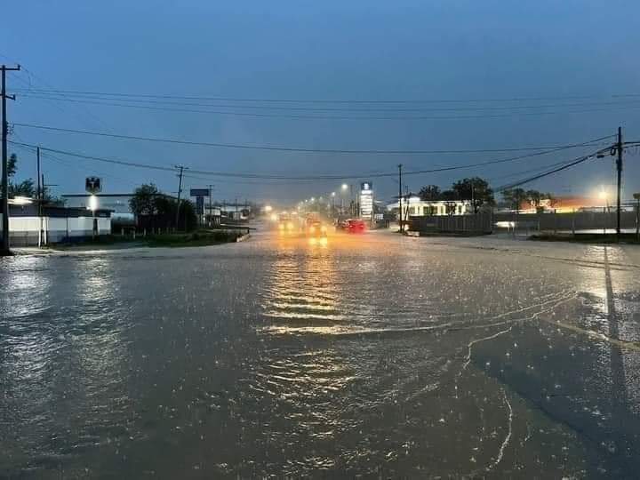
Another state that has experienced flooding in recent days is Nuevo León. Heavy rain on Sunday caused flooding in several parts of the northern state, including the metropolitan area of Monterrey, where harsh water restrictions have been in place in recent months.
In Cadereyta, a municipality about 40 kilometers east of Monterrery, four people died when the vehicle they were traveling in was swept away by floodwaters on Monday. Two women, a man and a child drowned, according to state Civil Protection authorities.
Governor Samuel García said on Twitter Monday that Civil Protection personnel had responded to more than 700 emergency calls and salvaged 95 stranded vehicles.
“The good news is that these rains have brought a great benefit to catchment areas, rivers, streams and dams,” he wrote on Twitter. “The rain is a blessing at the moment.”
On Instagram, the governor said Wednesday that the La Boca dam, located south of Monterrey, was 70% full. Before the recent rains, the dam was in its “dying days,” he said.
García also noted that the El Cuchillo dam was 62% full compared to 39% “before the rains” and that the Cerro Prieto dam was at 11% of capacity, up from 0%. He asserted that Nuevo León would soon exit its water crisis and that the rain would allow authorities to improve water service to citizens.
Meanwhile, Hurricane Kay, which strengthened into a Category 2 storm on Wednesday and as of Thursday morning, remains a threat to the Baja California peninsula. The United States National Hurricane Center (NHC) said at 7 a.m. Central Time that the hurricane was about 135 kilometers west of the Cabo San Lázaro and moving north-northwest at 22 km/h.
It said that Kay has weakened slightly, but the hurricane still has maximum sustained winds of 140 kilometers per hour with higher gusts. A hurricane warning is in effect for north of Punta Abreojos to San José de las Palomas, while a hurricane watch is active for Puerto Cortés to Punta Abreojos. Those locations are all in Baja California Sur.
“Hurricane conditions are expected within the hurricane warning area beginning on Thursday, and are possible within the hurricane watch area Thursday,” the NHC said.
“A dangerous storm surge is likely to produce coastal flooding near where the center passes the coast in areas of onshore winds, or east of the center if Kay makes landfall along the western Baja peninsula of Mexico. The surge will be accompanied by large and destructive waves.”
With reports from Infobae, El País, Excélsior, Aristegui Noticias and El Universal