
Hurricane Genevieve briefly reached Category 5 in the early hours of Monday, becoming the first cyclone of this magnitude recorded in the eastern Pacific since Hurricane Kristy in 2024, the U.S. National Hurricane Center (NHC) reported.
As of 9 a.m. CST on Monday, the NHC said Genevieve was located approximately 855 kilometers south-southwest of the southern tip of Baja California Sur, with maximum sustained winds of 250 kilometers per hour and wind gusts up to 305 kilometers per hour.
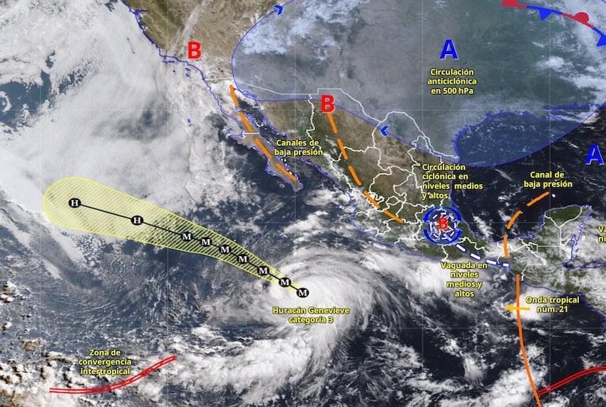
The system was moving northwest at 20 kilometers per hour on a track that kept it offshore and parallel to the Mexican coast, and is expected to maintain a west-northwest to northwest track over the next two days, gradually slowing its speed.
Despite the hurricane’s strength, forecasters have ruled out any direct impact on Mexican territory, with no coastal watches or warnings in effect.
However, the generated swells are already affecting Mexico’s southwest coast and are expected to reach southern Baja California, with the risk of potentially dangerous rip currents.
Rainfall forecast for most states
According to the National Meteorological Service (SMN), cloud bands from Genevieve in the Pacific Ocean will increase the likelihood of heavy to very heavy rains in western Mexico, coinciding with the Mexican monsoon in the northwest and Tropical Wave Number 21 in the south, which will intensify the storms.
The SMN said very heavy rains are expected on Monday in at least 17 states, with particular intensity in Sonora, Oaxaca and Chiapas.

Here’s the rain forecast for Monday afternoon:
Very heavy rain with isolated intense downpours (75 to 150 millimeters): parts of Veracruz, Oaxaca, Chiapas and Tabasco.
Heavy rain with isolated and very heavy downpours (50 to 75 millimeters): parts of Sonora, Chihuahua, Durango, Sinaloa, Nayarit, Jalisco, Colima, Michoacán, Guerrero and Puebla.
Showers with isolated heavy downpours (25 to 50 millimeters): parts of Hidalgo, México state, Mexico City, Tlaxcala, Morelos, Campeche, Yucatán and Quintana Roo.
Periods of showers (5 to 25 millimeters): parts of Baja California, Baja California Sur, Tamaulipas, Zacatecas, San Luis Potosí, Guanajuato and Querétaro.
Isolated rain (0.1 to 5 millimeters): parts of Coahuila, Nuevo León and Aguascalientes.
With reports from Radio Fórmula and the Associated Press