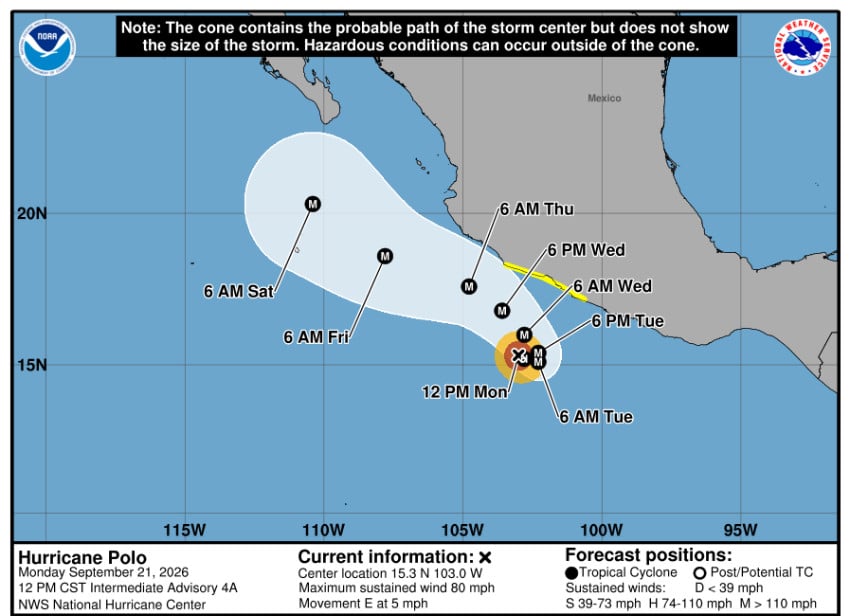
Hurricane Polo is expected to quickly intensify after forming Monday morning in the Pacific Ocean off the coast of Guerrero, with Civil Protection encouraging residents of several states to remain vigilant and follow safety recommendations.
Polo could bring heavy rain, rough surf and tropical-storm-force winds to parts of Mexico this week as it intensifies into a Category 5 hurricane near the coast of Michoacán by Wednesday, the U.S. National Hurricane Center warned.
⚠️ #Polo ahora como #Huracán categoría 1 ⚠️
◾️Se localiza a 305 km al sur-suroeste de Zihuatanejo, #Guerrero, y a 435 km al sur-sureste de Manzanillo, #Colima
◾️Su circulación refuerza la psibabilidad de #Lluvias de distintas intensidades en Jalisco, Colima, Michoacán, Guerrero… pic.twitter.com/3RRiy2j0PQ— Coordinación Nacional de Protección Civil (@CNPC_MX) September 21, 2026
It was centered about 410 kilometers south-southeast of Manzanillo, Mexico, and 322 kilometers southwest of Zihuatanejo at 9 a.m. CST on Monday. As of 12 p.m., it was a Category 1 storm with maximum sustained winds of 129 kph (80 mph).

Mexico’s National Meteorological Service (SMN) predicted Monday that Polo would bring heavy rainfall to Pacific coastal regions, potentially raising river and stream levels, triggering flooding and mudslides.
Intense rain is expected over the coming days in the states of Oaxaca and Guerrero (75 to 150 millimeters), very heavy rainfall (50 to 75 mm) in Michoacán, and heavy rainfall (25 to 50 mm) in coastal Jalisco and Colima.
Winds of 10 to 20 kph, with gusts of 30 to 50 kph, can also be expected along the coasts of Colima, Michoacán, Guerrero and Oaxaca. In addition, the storm will bring waves of 1 to 3 meters to Guerrero, Michoacán, Oaxaca, Jalisco and Colima.
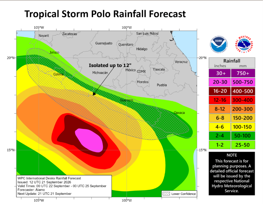
Officials urged the public to remain attentive to the warnings issued by Mexico’s National Meteorological Service (SMN) and to follow the recommendations of Civil Protection.
The SMN and the U.S. National Hurricane Center established a watch zone from Tecpan de Galeana, Guerrero, to Punta San Telmo, Michoacán, warning that Polo’s trajectory will be “erratic.” It is expected to curve and move parallel to the coasts of Colima, Michoacán and Guerrero.
Farther west in the Pacific Ocean, Tropical Storm Odalys is forecast to become a hurricane by mid-week. It was located over 2,000 kilometers west-southwest of the southern tip of Mexico’s Baja California peninsula on Monday morning.
In September 2024, Hurricane John hit coastal Guerrero as a Category 3 storm, just one year after Category 5 Hurricane Otis devastated Acapulco, one of Mexico’s main tourist destinations with a population of over one million people, from which it is still recovering.
With reports from AP News