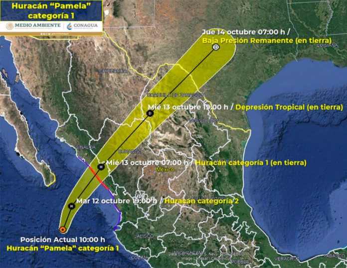
Hurricane Pamela is forecast to be near major hurricane strength before it makes landfall in Sinaloa on Wednesday morning.
A hurricane warning is in effect for Bahía Tempehuaya to Escuinapa, Sinaloa, and tropical storm warnings have been declared for Bahia Tempehuaya to Altata, Sinaloa, and Escuinapa to Cabo Corrientes, Jalisco, and the Islas Marías. In Baja California Sur, there is a tropical storm watch in effect from Los Barriles to Cabo San Lucas.
The center of the Category 1 hurricane was about 400 kilometers southwest of Mazatlán, Sinaloa, and 298 kilometers south-southeast off the southern tip of Baja California at 10:00 a.m. CDT according to the U.S. National Hurricane Center’s latest advisory. Its maximum sustained winds were 130 kph and it was moving northwards at 20 kph.
“This general motion should continue this morning, followed by a faster northeastward motion by this afternoon or tonight … the center of Pamela will pass well south of the southern tip of the Baja California peninsula through tonight, and make landfall in west-central Mexico within the hurricane warning area Wednesday morning,” the advisory said.
Winds with gusts of 80 to 100 kph and waves of three to five meters are expected off the coasts of Baja California Sur, Nayarit and Sinaloa Tuesday. Intense rainfall of 75 to 150 millimeters is predicted for Baja California Sur and Sinaloa.
Hurricane conditions are expected from Bahía Tempehuaya to Escuinapa late Tuesday or early Wednesday with tropical storm conditions arriving Tuesday evening. Tropical storm conditions could be seen in Baja California Sur Tuesday afternoon.
“Significant coastal flooding and large and destructive waves will affect areas near where the center of the hurricane makes landfall Wednesday. Sinaloa and western Durango will see about 100 to 200 mm of rainfall with isolated totals of 300 mm, which could trigger significant and life-threatening flash flooding and mudslides.
Swells generated by Pamela will begin to affect portions of Baja California Sur, southwestern and west-central mainland Mexico Tuesday. They are likely to cause life-threatening surf and rip current conditions, the National Hurricane Center said.
Sinaloa Governor Quirino Ordaz Coppel met with Civil Protection officials Monday to prepare for Pamela’s arrival.
The state Civil Protection chief Juan Francisco Vega Meza confirmed there were 128 temporary shelters available with capacity for up to 64,000 people.
He added that the state government requested a declaration of emergency from federal Civil Protection authorities for the municipalities of Navolato, Culiacán, Elota, Cosalá, San Ignacio, Mazatlán, Concordia, Rosario and Escuinapa.
With reports from Milenio
