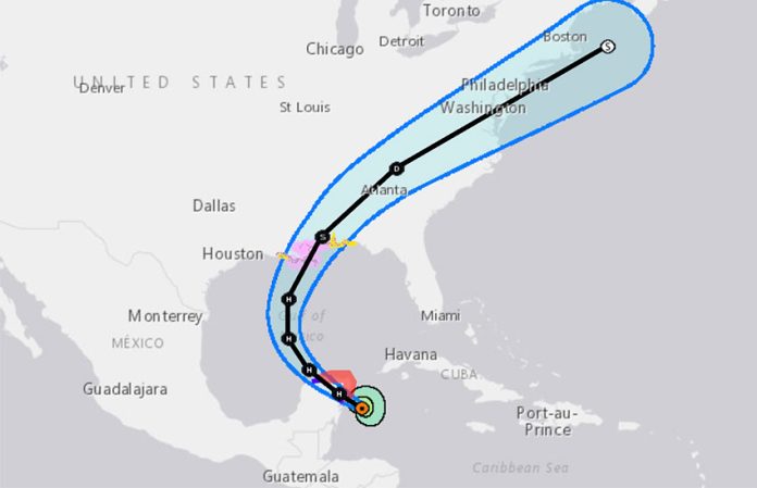
Hurricane Zeta has triggered a hurricane warning for portions of the Yucatán Peninsula.
The latest updates from the U.S. National Hurricane Center continues to put Cozumel and the area from Tulum, Quintana Roo, to Dzilam, Yucatán, in Hurricane Zeta’s sights, with hurricane warnings issued for both areas. Hurricane-force winds and heavy rains are expected by Monday evening.
A tropical storm warning is also in effect from south of Tulum to Punta Allen, as well as west of Dzilam to Progresso. Tropical storm-strength winds are also expected to arrive in the area by this evening.
A hurricane warning advisory means that hurricane conditions are expected somewhere within the warning area within the next 12 hours. A tropical storm warning means that tropical storm conditions are expected somewhere within the warning area within 12 to 24 hours.
Zeta is expected to spend tonight and early Tuesday over the Yucatán Peninsula. Zeta’s maximum sustained winds were near 130 kilometers per hour at 3:00 p.m. CST, with higher gusts, but winds could strengthen before Zeta makes landfall. Some weakening is likely while Zeta moves over the peninsula, but it is forecast to strengthen again when it moves over the southern Gulf of Mexico on Tuesday.
Storm surges are possible when Zeta makes landfall, raising water levels more than one meter above normal tide levels.
Zeta was located 145 kilometers southeast of Cozumel at 3 p.m. and moving northwest at about 17 kilometers per hour.
After passing through Mexico, Zeta is predicted to move on towards Morgan, Louisiana, and the northern Gulf Coast, to the Mississippi–Alabama border, by Wednesday.
Mexico News Daily
