Meteorologists are tracking two Atlantic systems that may develop into tropical storms this week.
The first, off the coast of Florida, appears unlikely to become a storm, though it is expected to dump rain on the already drenched state.
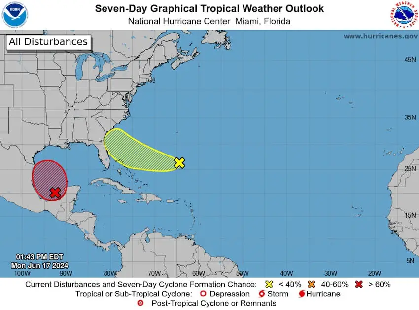
The other low pressure system in the Gulf of Mexico has the potential to become the first Atlantic tropical storm of 2024, with forecasters predicting a 70% chance of it strengthening by midweek.
In a statement updated at 12 p.m. Mexico City time on Monday, the U.S. National Hurricane Center said “a tropical depression or tropical storm is likely to form by midweek while the low moves slowly west-northwestward toward the western Gulf coast,” adding that “tropical storm watches and warnings may be required for portions of this area later this afternoon or tonight.”
Torrential rains continue in the forecast for southeastern Mexico, as well as lightning storms and hail. Residents of Chiapas, Yucatán and Quintana Roo are warned to be on the lookout for mudslides and should be alert to flash floods.
Several municipalities in Chetumal in southeastern Quintan Roo canceled classes on Monday due to the heavy rains, according to newspaper La Jornada Maya. Officials also closed down several roads close to Chetumal Bay and along the Hondo River. On Sunday night, the National Guard (GN) began executing an evacuation plan in Chetumal, opening temporary shelters for those affected by flooding.

The national weather agency’s Monday forecast anticipates torrential rains along the Oaxaca coast, as well as in Chiapas, Tabasco, Campeche, Yucatán and Quintana Roo. Heavy rains are predicted for Veracruz and parts of Puebla. High winds are forecast for the Yucatán Peninsula, with gusts reaching 60-80 km/h, while windy conditions and a downpour are forecast for Guerrero on the west coast.

At the same time, the SMN has identified another low-pressure system stretching from northeastern Mexico to the west coast and down toward the country’s midsection that is being fed by moisture coming in from the Pacific Ocean. Heavy rains are forecast for Chihuahua, Durango, Sinaloa, Coahuila and Tamaulipas up north, as well as in the Pacific Coast states of Nayarit, Jalisco, Colima and Michoacán.
The torrential rains and tropical storms are in keeping with the forecasts of meteorologists expecting a rainy month in much of Mexico.
With reports from Proceso, La Jornada Maya and Aristegui Noticias