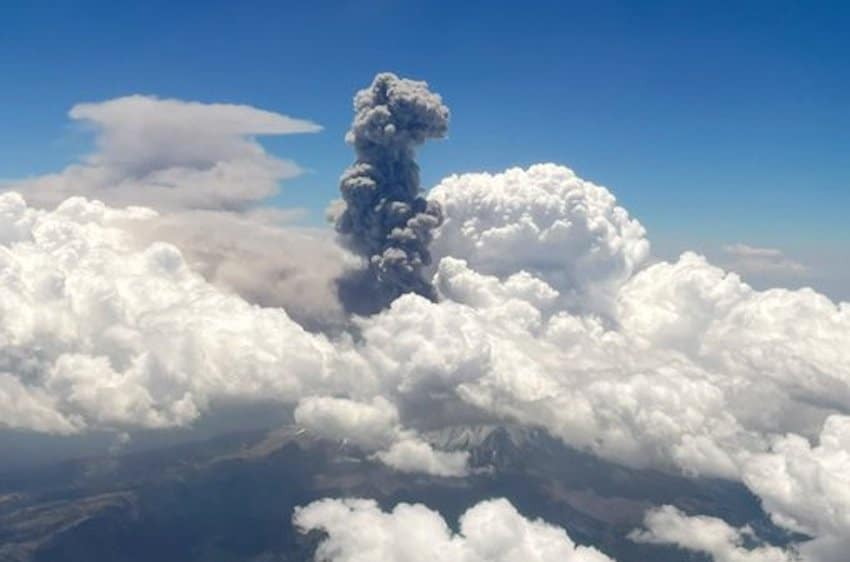
The Popocatépetl volcano has registered recent intense activity, putting the area on high alert.
The government of Puebla city and other surrounding municipalities are reviewing evacuation routes and shelters to prepare for explosive activity. In the last 24 hours, 94 emissions of water vapor, gasses and ash were registered by the monitoring systems of the National Autonomous University of Mexico (UNAM) and the National Center for Disaster Prevention (CENAPRED).
“The explosions taking place inside Popocatépetl… are a normal phenomenon and not necessarily indicative of increased volcanic activity,” the institutions emphasized in a joint statement. Both stressed that the volcano is being monitored. Reports will be published daily at 11 a.m. summarizing the past 24 hours of volcanic activity. Any abnormal events are reported immediately, officials said.
An explosion of incandescent material on Monday morning can be viewed on the Webcams de México Twitter account.
Current volcanic activity represents a Phase 2 Yellow Alert on the Volcanic Alert Traffic Light (Semáforo de Alerta Volcánica) emergency system, activating a security radius of 12 kilometers around the volcano past which the public is forbidden from entering.The warning indicates an increase in activity and warns of light to moderate ashfall in nearby areas, as well as the possibility of mudslides and debris flow.
Already, ashfall has prompted health authorities to recommend that residents use face masks, as it poses a considerable risk of respiratory disease and conjunctivitis. The Health Ministry recommends that residents of the following municipalities use face masks and, in some cases, protective eyewear:
- Santiago Xalitzintla
- San Nicolás de los Ranchos
- San Pedro Benito Juárez
- Guadalupe Huexocuapan
- Atlixco
- Cuautlancingo
- Huaquechula
- Ocoyucan
- Puebla
- San Andrés Cholula
- San Diego La Mesa Tochimilzingo
- San Gregorio Atzompa
- San Jerónimo Tecuanipan
- San Pedro Cholula
- Santa Isabel Cholula
- Teopantlán
Authorities also urged citizens to focus on warnings by state and municipal governments or the Ministry of Defense and to avoid paying attention to alarmist content. All measures and evacuation routes have been planned, they said, although evacuation will only occur once the volcano reaches a Red Alert on the Traffic Light system.

According to the Public Security Ministry, over 3,000 vehicles are prepared to evacuate the 13,000 inhabitants living in the risk area.
With reports from Sin Embargo, Expansión and Cenapred-UNAM