The Yucatán Peninsula is bracing for intense rainstorms on Thursday as Hurricane Rafael slowly makes its way into the south-central region of the Gulf of Mexico.
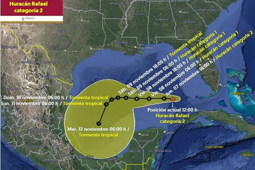
Rafael — a Category 2 hurricane as of 2 p.m. Mexico City time Thursday, down from a Category 3 on Wednesday afternoon — was about 350 kilometers north-north-east of Cabo Catorche, Quintana Roo, according to Mexico’s National Water Commission (Conagua).
Rafael’s arrival in Cuba Wednesday as a Category 3 storm took out the island nation’s power grid with over 200 km/hr winds and brought flooding and heavy damage to Havana, Mayabeque and Artemisa, according to President Miguel Diaz-Canel’s account on the social media platform X. Cuba was still experiencing residual rains from the storm on Thursday afternoon even as the storm headed toward the Gulf of Mexico.
Current models have Rafael moving slowly west over the weekend before turning slightly southwest early next week, according to the U.S. National Hurricane Center. If the model holds (initial models had Rafael heading toward the U.S. Gulf Coast), the hurricane is likely to weaken as it veers toward the southwest Gulf of Mexico in the direction of the states of Veracruz and Tabasco.
Conagua reported that as of noon, Rafael was featuring sustained maximum winds of 155 km/hour, gusts of up to 195 km/hour and was moving northwest at 15 km/hour. The advisory also warned that the hurricane’s outer bands would increase humidity across the peninsula, stoking heavy rain (25 to 50 mm) in the states of Yucatán and Quintana Roo, as well as cloudbursts in Campeche on the southwestern side of the peninsula.
A hazardous weather outlook was also issued for Yucatán and Quintana Roo as Conagua warned that the outer bands would bring winds of up to 60 km/hour while also producing waves reaching up to 2 meters in height on Thursday afternoon.
Yucatán’s Civil Protection authorities advised residents in eastern, central and southern municipalities to take precautions as storm conditions worsened throughout the day, according to the newspaper Diario de Yucatán.

Mexico’s National Meteorological Service (SMN) expects Rafael to weaken throughout the weekend, with maximum sustained winds dipping to 65 km/hour by Tuesday.
If the forecast holds, Rafael would be downgraded to a tropical storm and not make landfall in Mexico, according to the newspaper Milenio. Instead, the storm would dissipate and drift north while remaining 400 kilometers or more off the coast of the state of Tamaulipas.
With reports from Milenio and Diario de Yucatán