The remnants of Hurricane Lorena continue to lose force, but the post-tropical cyclone could still wreak havoc in northwestern Mexico.
Coastal watches and warnings were issued for the Baja California Peninsula through the weekend, even as the National Hurricane Center (NHC) said Lorena would continue to weaken, dissipating by Sunday night.
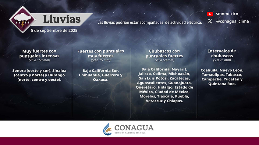
Despite its deterioration, Lorena’s cloud formations, combined with the Mexican monsoon, Tropical Wave 30 and other low-pressure systems inland, were forecast to produce significant rainfall across much of the country throughout the day.
The National Water Commission (Conagua) is forecasting intense rain in the states of Sonora, Sinaloa and Durango on Friday, with up to 150 mm (6 inches) of rainfall. Baja California and Chihuahua could see up to 75 mm (3 inches) of rain, as could the coastal states of Guerrero and Oaxaca further south.
Conagua warned of landslides, rising river and stream levels, as well as flooding and overflows in low-lying areas. Officials urged residents to heed the warnings from the National Meteorological Service (SMN) and to follow the recommendations of Civil Protection agencies.
Officials in Baja California and Baja California Sur (BCS) issued flash flood warnings and cautioned residents to be on the alert for landslides, especially in areas with higher ground.
BCS officials ordered schools closed across the state on Friday and the Welfare Ministry suspended activities in the state.

As the storm’s outer bands remain powerful, BCS officials are preparing for an additional 200 mm (8 inches) of rain, as are officials in Sonora. Total rainfall in the region could exceed 300 mm (12 inches), the NHC said, since Lorena began lashing the peninsula on Wednesday.
Conagua warned of high winds crossing the Gulf of California, affecting the northern states of Chihuahua, Coahuila, Nuevo León, Tamaulipas and San Luis Potosí, alerting residents to the possibility of downed trees and billboards.
Swells generated by Lorena will continue to affect portions of the west coast of Baja California Sur through Friday, the NHC warned. As these swells can cause life-threatening surf and rip current conditions, residents are advised to heed instructions from local officials.
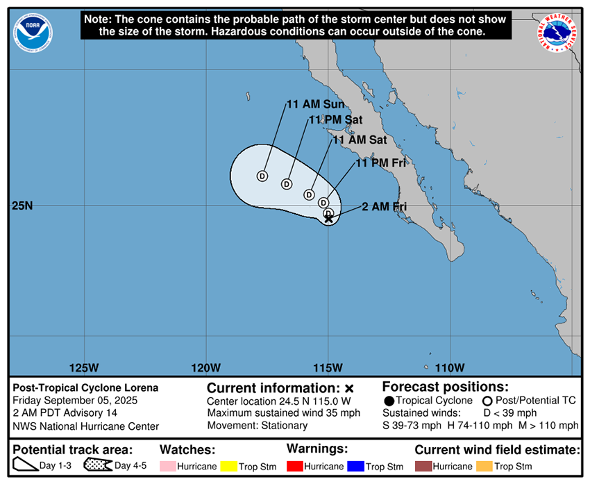
At 5 a.m. Friday, Lorena was roughly 170 miles west of Magdalena Bay and Cabo San Lázaro, Baja California Sur. Though categorized as stationary, it is forecast to move north-northwestward early Saturday before turning west-northwest over the rest of the weekend.
On Wednesday, Lorena was classified as a Category 1 hurricane, with wind speeds around 75 miles per hour while sitting off the coast of the Baja California Peninsula, but by Thursday morning it had weakened to tropical storm status.
Originally forecast to make landfall in Baja California, Lorena still had sustained winds of 35 mph, with gusts hitting 55 mph Friday morning.
The NHC said that as Lorena moves north-northwest, it could dump 1 to 2 inches of rain across the Southwest U.S., with isolated areas in Arizona and New Mexico seeing up to 4 inches.
With reports from El Financiero and Aristegui Noticias