

There are two things you may not know about the Municipality of Tequila.
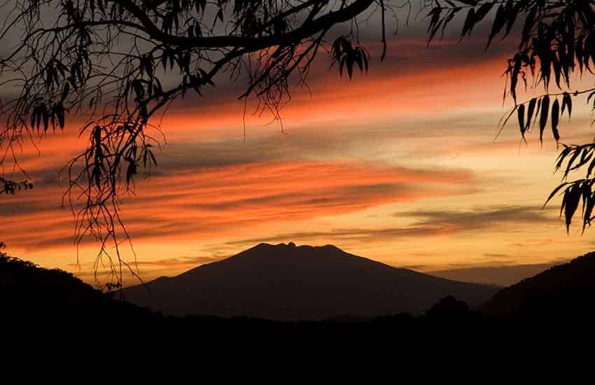
First, it is home to a great volcano, nearly 3,000 meters high, the most important landmark in the vicinity of Guadalajara.
Secondly, the very same municipality also encompasses a canyon 570 meters deep called La Toma Valley, featuring tropical foliage and picturesque waterfalls.
Tequila Volcano and La Toma Canyon are only 14 kilometers apart, with the town of Tequila in between. From the bottom of the canyon to the peak of the volcano is a vertical distance of over 2,000 meters.
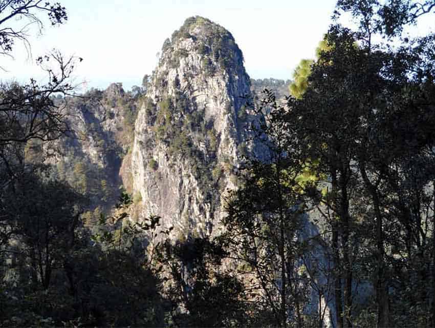
The highest point in Tequila is the tip of La Tetilla (The Nipple), a needle-like spine, or volcanic plug, that rises from the volcano’s crater. Here, at 2,920 meters (9580 feet) above sea level, you need to bring along a jacket, even on the hottest day of the summer. Believe it or not, it’s actually too high for pines and most other trees. So what you find at the very peak could be called “accidental bonsais:” stunted trees that can only grow as high as a bush.
This is the situation at the spine, which rises 50 meters above the crater rim. People with rock-climbing skills can reach the top of this plug and will be treated to a curious view. At first sight, it appears that this volcano is almost entirely surrounded by lakes, but a closer look with binoculars proves that the lakes are actually great fields of Weber azul, the blue agave, from which Tequila’s most famous export is distilled.
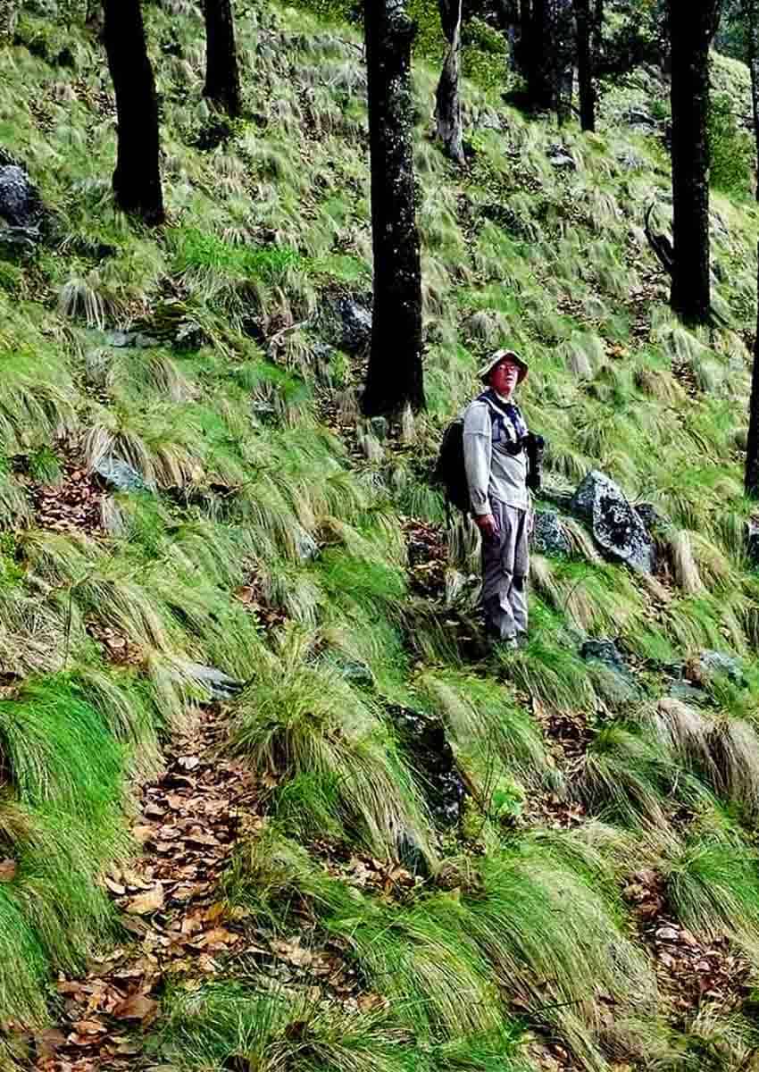
Although vegetation is sparse on La Tetilla, conditions are quite different inside the crater around it. Unlike many volcanic craters whose ashy slopes are barren of life, the interior of Tequila’s is what I would call glamorous: filled with beautiful pines and oaks and carpeted by high bunchgrass, which gently waves in the breeze, just as beautiful in the dry season as in the rains.

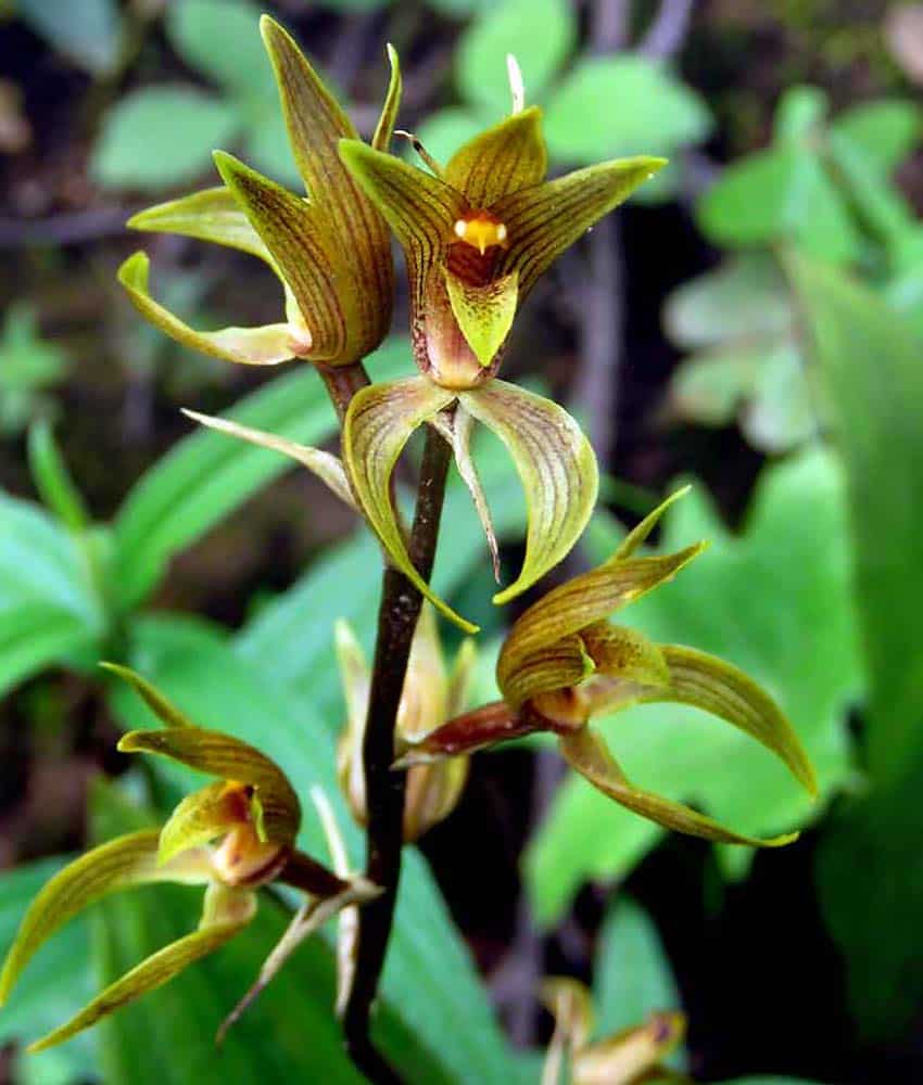
In fact, a walk along the 700-meter-long path crossing the crater is among the most picturesque of some one hundred hikes I’ve described in Western Mexico over the past 40 years. Here you may spot a small white Govenia orchid that grows not in tree branches but on the ground, often right next to the path.
Or you may come upon a delicate mountain violet or butterwort, a carnivorous plant which traps tiny insects on its sticky broad leaves that lie flat on the ground around the stem.
You can easily reach the top of the volcano from the town of Tequila — if you have a high-clearance vehicle — thanks to a 16 kilometer cobblestone road which winds its way up to the microwave antennas perched on the crater rim. When you reach a locked gate near the top, you must park and here is where your hike begins.
First, you walk up the cobblestone road for 1.6 kilometers to the trail head of the path through the crater. On the way, you’ll pass a perennial spring of delicious cold water. If it’s the rainy season, you may be enveloped in clouds of fog that whisk across the mountain, one after the other. For more info and directions, see Beat the heat in crater of the Tequila Volcano.
The volcano lies on the south side of Tequila, while at the northern edge of the city you find a steep cliff with a Machu-Picchu style trail winding its way down the canyon to three incredible cascades known as Los Azules.
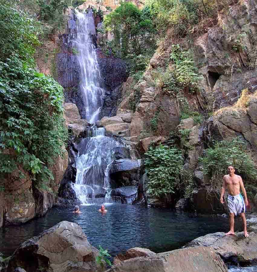
These waterfalls measure 60, 40 and 70 meters, and at the bottom of the second and third drop, there are spectacular pools that you’d only expect to see in a tropical paradise or in a Hollywood movie. The water is neither hot nor cold but just the right temperature for bathing, and because it comes from natural springs — not runoff — it is perfectly clean and unpolluted.
The trail leading down to the second pool, which is the most picturesque, is steep and rough, but if you are in good shape, it’s well worth the effort. The easiest way to reach the pool without getting lost is with the help of a local person. Just tell anyone in Tequila that you want to go to Los Azules, and you will very quickly have your pick of guides. Do this on a weekday, and you will probably have the whole place to yourself — and the friendly blue and red dragonflies that will no doubt come to see who is visiting their paradise today.
Only 1.2 kilometers from Los Azules, there is another wonderful waterfall known as La Toma, which has been turned into a balneario, (water park) offering a magnificent view of the spectacular valley, the upper half nearly covered with tequila agaves and the deeper parts filled with lush tropical vegetation.
The balneario is only a 12-minute drive from Tequila, and you can easily find your way there by asking Google Maps to take you to La Toma, Tequila, Jalisco.
Would you like to get closer to that lush, tropical vegetation? Just drive 1.2 kilometers below Balneario La Toma to the shrine of Santo Toribio, patron saint of migrants, who was shot to death in this valley in 1928 during the Cristero War.
Here you’ll find what’s left of Toribio’s secret hideout next to a large, elegant church built in his honor, surrounded by palm trees and exuberant foliage. Here the moisture-laden air is thick with butterflies and the piercing calls of exotic birds.
The locals grow mangoes, papayas and chirimoyas (custard apples), as well as curious, untranslatable fruits like mameyes and bomb-shaped bonetes.
While wiping the sweat from your brow, you may want to cast your eyes southward, where you just might spot the cold, barren, wind-swept peak of Tequila Volcano, 13 kilometers away.
Google Maps says you could drive there from the church of Santo Toribio in a mere 80 minutes — and along the way experience the unique biodiversity bonanza of ever-amazing Tequila, Jalisco.
The writer has lived near Guadalajara, Jalisco, since 1985. His most recent book is Outdoors in Western Mexico, Volume Three. More of his writing can be found on his blog.