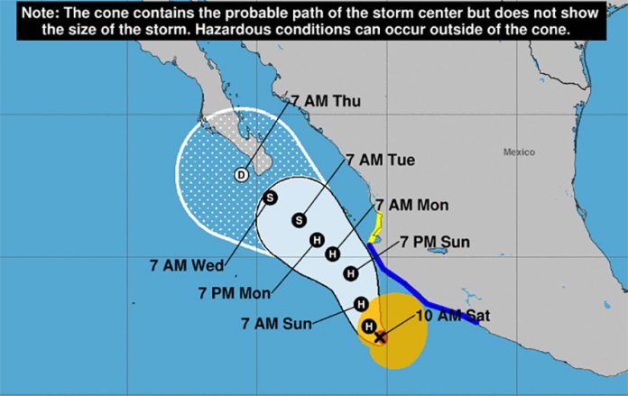
Hurricane Enrique, the first hurricane of the eastern Pacific season, formed Saturday morning off the coast of Michoacán. The storm is expected to grow stronger as it advances northwestward along the coast but forecasters predict it will remain offshore.
Enrique’s maximum sustained winds were clocked at 140 kmh at 10:00 a.m. CDT when the storm was located 370 km south of Cabo Corrientes, Jalisco, and moving west-northwest at 11 kmh.
It is expected to become a Category 2 hurricane by Sunday, the U.S. National Hurricane Center (NHC) said.
But the center of the storm is predicted to stay at sea, moving parallel with the coast.
The NHC also said the storm could bring 150 to 300 mm of rain with isolated maximum amounts of 450 mm to the coasts of Colima, Michoacán and Jalisco. Heavy rains are also expected in Chiapas, Oaxaca, Guerrero, Nayarit and southern Sinaloa, according to the Mexico’s National Meteorological Service (SMN).
A tropical storm warning is in effect from Zihuatanejo, Guerrero, to Cabo Corrientes, Jalisco.
SMN spokesman Jesús Montes said the rains could bring some relief from the drought that much of Mexico is currently experiencing, raising water levels in dams and other bodies of water. He added that trained personnel are standing by to provide help in the emergency service centers in Guerrero, Jalisco, Sinaloa, Michoacán, Nayarit and Colima.
The Defense Ministry said it was sending troops to aid civilians during the storm.
With reports from AP News and El Universal
