

Heavy rains and cold winds are predicted in eight Mexican states over the next few days as the result of a blast of arctic air combined with Tropical Storm Pilar, the National Meteorological Service (SMN) reports.
With the state of Guerrero still reeling from Hurricane Otis, Pilar formed on Sunday in the Pacific Ocean off the coast of Central America, becoming the 16th named cyclone of the season.
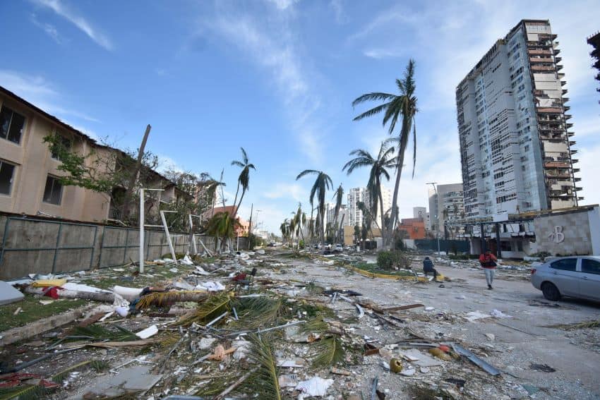
Located off the west coast of El Salvador, Pilar does not represent severe danger to Mexico. However, with Otis’ sudden turn into a deadly, destructive Category 5 hurricane at landfall last week, forecasters are paying extra attention to the storm.
On Tuesday morning, the SMN issued an alert for “torrential and extraordinary” rain along with “strong, icy winds and high waves in the states of Tamaulipas, Veracruz, Tabasco, Campeche, Yucatán, Chiapas, Oaxaca and Quintana Roo.”
Very strong rains, including thunderstorms and possible hail, are also expected in Puebla, Michoacán and Guerrero. The bad weather should last through Thursday, said Alejandra Méndez, the head of the SMN.
The cold front–tropical storm combination also will cause a drop in temperatures, fog and drizzle over Mexico’s northern and northeastern states, and gusts of up to 80 km/h (50 mph) on the Caribbean coasts of Tamaulipas and Veracruz.

Tabasco entered a state of yellow alert on Tuesday morning, with officials asking the population to take precautions in the event of flooding. There are also concerns over reduced visibility and landslides in the area.

Meanwhile, sleet or snow is expected in the mountainous areas of Chihuahua, Coahuila and Nuevo León, as well as on some of Mexico’s tallest peaks, such as Citlaltépetl and Popocatépetl.
In México state, lows of 4 to 6 Celsius are expected, with lows of 7 to 9 Celsius in Mexico City.
This year’s Pacific storm season has seen 10 hurricanes (Adrian, Beatriz, Calvin, Dora, Fernanda, Hilary, Jova, Lidia, Norma and Otis) and six tropical storms (Eugene, Greg, Irwin, Kenneth, Max and Pilar).

Pilar’s center was about 260 km (161 miles) south of San Salvador as of 1 p.m. Tuesday, with sustained winds of 85 km/h (53 mph), according to the U.S. National Hurricane Center.
Méndez noted that its movement “is erratic,” but after a short push toward Central America, Pilar is expected to head back out to sea by Thursday, in part because it will be blocked by runoff from the arctic air mass.
With reports from La Jornada and Infobae