The Copalita Trail is 100 kilometers long — 70 kilometers of walking and 30 of rafting—and includes five nights of camping “in a million-star hotel.” It starts in high mountains at 3,200 meters (10,500 feet), passes through five ecosystems, takes you down the Copalita River, and ends at sea level on a gorgeous Pacific Coast beach.
The trek is a project of nine Zapotec communities in Oaxaca and has much to do with environmental education and conservation. It was organized by biologist Marco Antonio González some fourteen years ago.
Visiting Zapotec villages
The Zapotecas consider the trekkers collaborators rather than clients, and refer to them as “visitors.” At no point during the experience does money change hands and it is unthinkable that a trekker would tip anyone.
These caminatas are fully orchestrated. Six local guides accompany the trekkers at all times and the route they follow varies according to the circumstances of the moment, in a very Mexican fashion.
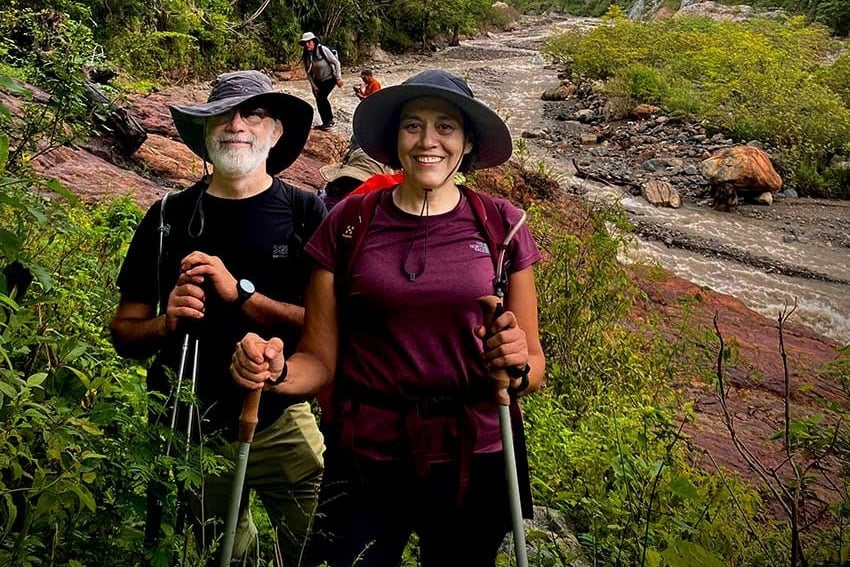
A couple from Guadalajara, Paulina Ascencio and Arturo Sánchez, signed up for the trek in October of this year.
“It started in Oaxaca City,” Arturo told me. “Marco Antonio gave us an orientation and we were then driven seven hours to San Sebastián Río Hondo, where we enjoyed a meal prepared over a wood-burning stove: carne asada, frijoles and hand-made tortillas … delicious! Then we were driven to our campsite near San Juan Ozolotepec, which had tents and dry toilets.”
“The next day,” continued his wife, Paulina, “we walked 16 kilometers through an area simply bursting with biodiversity. The variety of mushrooms we saw was astounding.”

From guacamole to grasshoppers
“As for the food on this trip,” she continued, “it was incredibly good: guacamole, cottage cheese, yellow mole, frijoles with avocado leaves, grasshoppers, bananas roasted on hot coals and delicious wild-mint tea! And throughout those six days, not a soul had stomach problems!”
The first day of hiking brought the group to Rancho Obispo near San Francisco Ozolotepec, which is only 200 meters lower in altitude than the first campsite.
Ozolotepec in these place names means “Hill of the Jaguar” in Nahuatl. For the Zapotecs and Mixtecs of Oaxaca, the jaguar represented strength, mystery and the underworld.
A horse for an ambulance
The following day, the “visitors” were on the trail for nine hours, during which they lost 2,000 meters of altitude. Also on the trail were mules carrying their equipment, along with a horse dubbed La Ambulancia.
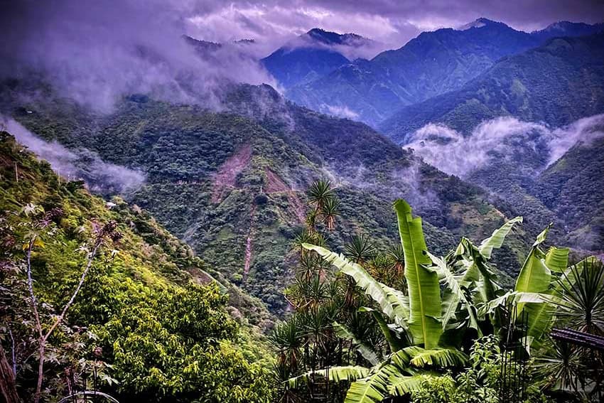
“It was green, green, green and down, down, down with spectacular views!” says Paulina Ascencio. “Now we were in an agricultural area where they use the traditional milpa system: corn, beans and squash, all growing together. This is also the area where they grow Café Pluma, which is said to be the very best coffee produced in Mexico.
“And at last we reached a river. What a joy it was to put our tired feet into the bubbling water.”
Then it began to rain, which slowed the group down. Eventually, the rain turned into a ferocious storm and a dramatic river crossing. After 12 hours of hiking, they arrived at San José Ozolotepec, altitude 1,223 meters, a town that can only be reached on foot. Here they slept in a churchyard because the normal campsite had been damaged by a hurricane.
River walking
There are normally only six hours of hiking on day four, following a river through mango orchards and coffee plantations, leaving plenty of time to visit local caves with rock art going back to Neolithic times. In reality, this little group of hikers ran into a second day of heavy rain, which doubled the amount of walking time.
Says Paulina Ascencio:
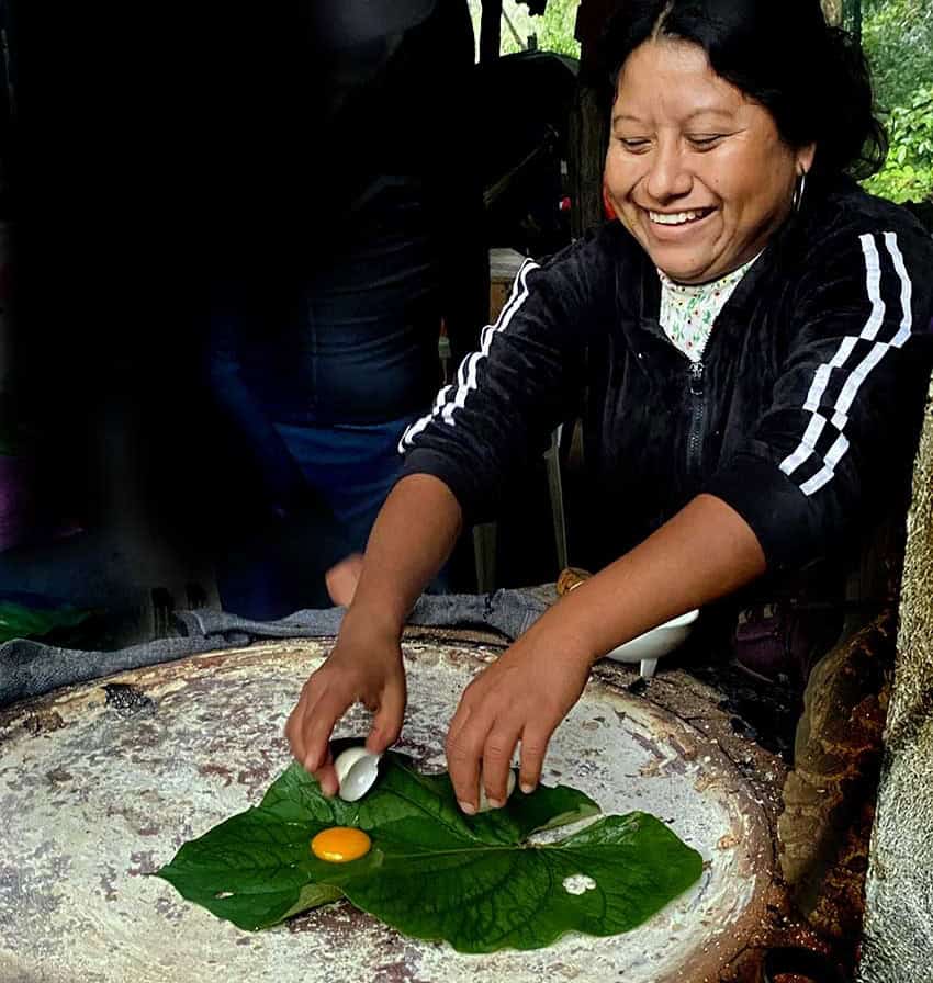
“At 9 p.m., we arrived at San Felipe Lachilló, dripping wet, but feeling great. The next day, we went to a nearby spring of wonderfully transparent water, which is channeled into several big swimming pools. They call this place Yuviaga. Above the spring, there is a kitchen where we had the best food of the trip. Take the eggs, for example. They start with a large green leaf called hoja santa, which they put on the hot comal. Once the leaf is pliable, they break an egg on it, wrap the egg in the leaf and roast it. Then you eat it with frijoles, salsa and nopales. Delicious!”
Jungles and junk food
The final day of hiking included only 12 kilometers of walking and took the trekkers through an old coffee plantation, followed by jungles filled with huge trees, after which they arrived at San Miguel del Puerto, the first town they had seen on the entire excursion.
“We walked into a little shop,” said Arturo, “and couldn’t resist buying junk food and beer. Thus fortified, we came to our last campsite at a place called Mandimbo, which has an incredible botanical garden. Here we saw many of the plants we had been eating throughout the trek. They even showed us a bromeliad named after this village. Then we walked to the campsite, at the top of a little hill, underneath a beautiful palapa, where all of us took showers around the back, under a hose.”
The last day of the trek features rafting down the Copalita River, a haven for hundreds of bird species, finishing up on La Bocana Beach, known for its great surfing waves and mud baths, at a restaurant famed for its delicious mariscos (seafood). From here, a bus takes people to their hotels in Huatulco.

Does this sound like your kind of adventure? If so, you’ll find full information on the Camino Copalita website, which is in English. Happy trekking!
John Pint has lived near Guadalajara, Jalisco, for more than 30 years and is the author of “A Guide to West Mexico’s Guachimontones and Surrounding Area” and co-author of “Outdoors in Western Mexico.” More of his writing can be found on his website.