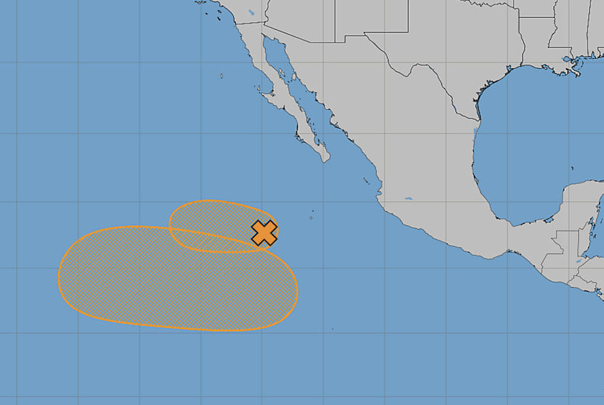
Mexico’s National Meteorological Service (SMN) is closely monitoring two weather systems in the Pacific Ocean, with concerns that they could develop into hurricanes in the coming days.
By Wednesday morning, the Tropical Wave 8 weather system was located 760 kilometers southwest of Cabo San Lucas in Baja California Sur and moving in a west-northwest direction at a forward speed of 24-32 km/h. It had a 50% probability of cyclonic development within 48 hours as well as over the following seven days, according to Mexico’s National Water Commission (Conagua).
Se mantiene en vigilancia una zona de #BajaPresión al suroeste de las costas de #BajaCalifornia, con 50 % de probabilidad para desarrollo ciclónico en 48 horas y en 7 días. Asimismo, se prevé la formación de otra zona de baja presión en la misma región ⬇️ pic.twitter.com/JWgv6DFwdf
— CONAGUA Clima (@conagua_clima) June 24, 2026
The SMN also identified the imminent formation of a second low-pressure area in the same region, with a higher cyclonic development probability of 60% for the next seven days. Both systems are located over warm waters, which could cause them to intensify more.
If these systems strengthen to reach sustained winds exceeding 63 km/h, they will be classified as tropical storms and assigned the names Douglas and Elida, as designated by the official 2026 season list.
The possibility of a Fujiwhara Effect
Experts are following the situation closely because the proximity of the two storms to each other could lead to a rare phenomenon known as the Fujiwhara Effect, which would happen if they both strengthen and approach each other closely.

The Fujiwhara Effect is named after the Japanese meteorologist Sakuhei Fujiwhara, who was the first to describe the behavior of two tropical storms as they approach each other.
When two active tropical systems are within approximately 1,400 kilometers of each other, the circulation patterns of both can influence each other, and the systems can begin to rotate around a common point, generating a kind of spiraling atmospheric dance.
One of two things can happen in such a case. Either the stronger storm can absorb the weaker one, increasing its intensity and destructive potential, or, if both systems are of similar intensity, they can orbit each other for several days before separating or potentially merging into a single weather phenomenon.
The Fujiwhara Effect complicates the prediction of hurricane movements, since meteorological models are not designed to simulate the trajectories of two storms interacting.
With reports from Informador, Record and Eje Central