As hurricane season in western Mexico begins, forecasters are monitoring two weather systems off Mexico’s Pacific Coast with the potential to transform into the first two hurricanes of the year, Amanda and Boris.
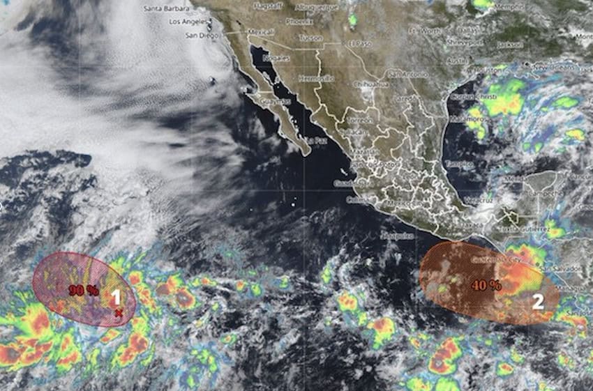
According to the National Water Commission (Conagua) and the National Meteorological Service (SMN), Amanda corresponds to a low-pressure area located southwest of the Baja California peninsula. The probability of cyclonic development is high — 90% in the next seven days — but it is already located 2,225 kilometers away from Mexico’s coastline and moving further out to sea at 16 kilometers per hour. Forecasters at the SMN say that even if it were to grow into a hurricane, it would not pose a risk to the country.
(SMN/Conagua)
Boris, on the other hand, has a lower probability of becoming a hurricane (40%). However, if it does form, which would be off the coast of Guerrero, Oaxaca or Chiapas, it would represent a higher risk due to its closer proximity to Mexican shores.
Conagua predicts above-average activity in the Pacific for this year’s hurricane season, and near or below the historical average in the Atlantic. That translates to between 18 and 21 tropical cyclones in the Pacific and between 11 and 15 hurricanes in the Atlantic.
Meteorologists will pay special attention to the Pacific, as the El Niño weather pattern is likely to form over the summer. This natural phenomenon causes anomalies in the water’s surface temperature that directly influence the global climate and the formation of hurricanes.
Weather forecast for Tuesday
The SMN forecasts significant rainfall in eastern and southeastern Mexico, and in parts of central Mexico, associated with a low-pressure system and other atmospheric conditions.
The rainfall forecast for Tuesday:

- Intense rainfall (75 to 150 millimeters) in parts of Puebla, Veracruz, Oaxaca, Tabasco and Chiapas.
- Very heavy rainfall (50 to 75 millimeters) in parts of Jalisco, Michoacán, Morelos, Guerrero, Campeche and Yucatán.
- Heavy rainfall (25 to 50 millimeters) in Coahuila, Nuevo León, Tamaulipas, San Luis Potosí, Zacatecas, Aguascalientes, Colima, México state, Tlaxcala and Quintana Roo.
- Showers (5 to 25 millimeters) in Chihuahua, Durango, Nayarit, Guanajuato, Querétaro and Hidalgo.
With reports from El Financiero and El País