

More than a dozen environmental organizations this week accused the government of covering up an oil spill that has despoiled some 630 kilometers of beaches along the Gulf coast.
Satellite imagery shared by Greenpeace and other nonprofits suggests the origin of the catastrophe dates to early February, but government officials didn’t acknowledge the problem until nearly a month later when complaints about oil slicks in the water and tar on Veracruz and Tabasco beaches became public.
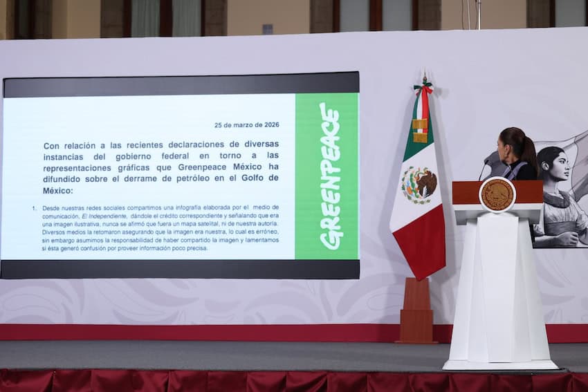
President Sheinbaum refuted the charges Thursday, accusing Greenpeace of using inaccurate imagery and unscientific data to alarm the public, and insisted that Pemex, the Navy and the Environment Ministry went to work immediately once the spill was discovered.
The state-owned oil company Pemex had earlier denied responsibility for the spill itself and Veracruz Governor Rocio Nahle — a former energy secretary with close ties to Pemex — blamed a privately owned vessel operating off the coast of Campeche, though an inspection revealed the ship in question was not responsible.
On Wednesday, NGOs led by Greenpeace and the Mexican Center for Environmental Law (Cemda) pointed a finger at the government, insisting that satellite images reveal early knowledge of the spill, insufficient containment and a lack of transparency.
That satellite imagery shows the spill originated near Pemex’s Abkatún platform as early as Feb. 6. Multiple vessels engaged in containment efforts were visible by Feb. 13 — evidence that authorities were already aware of the spill, the NGOs said.
In a press release, Cemda accused the government of mismanaging the disaster, saying “[t]here was no timely public information on the magnitude of the spill, its risks or the response measures.”

Although the National Contingency Plan “provides for immediate notification, incident assessment and inter-institutional coordination,” none of that took place, Cemda said.
By Feb. 14, “the oil slick covered approximately 50 km², or more than 1,000 times the size of Mexico City’s Zócalo,” Cemda says, adding that the failure to issue a public alert as required by law prevented coastal communities from taking preventive measures.
As of Wednesday, neither the Environment Ministry nor the Agency for Safety, Energy and Environment had published the Net Environmental Benefit Analysis or the Sensitivity Maps required to coordinate the official response.
However, nearly seven weeks after the initial spill, the oil slick has spread along 680 kilometers of the coastline with tar coming ashore on various beaches in Veracruz and Tabasco. The oil has also affected the Veracruz Coral Reef System, as well as six other natural protected areas.
With reports from La Jornada, Diario de Xalapa, Proceso and Reforma