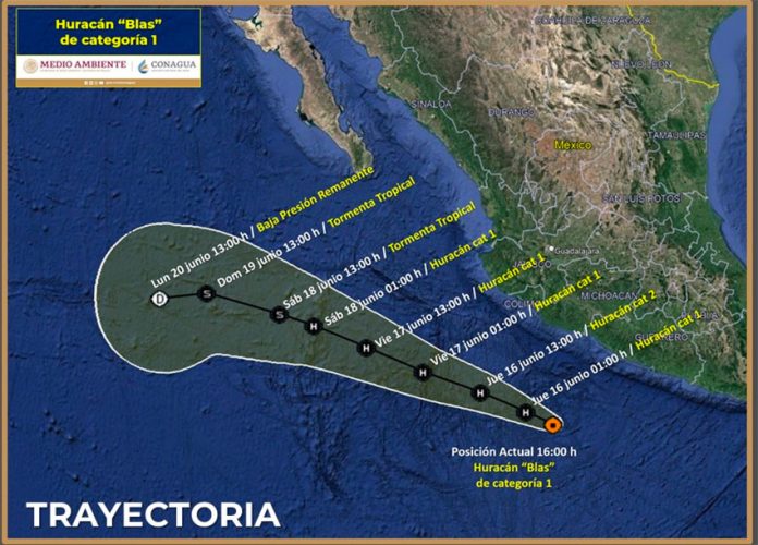
Hurricane Blas, a Category 1 storm located off Mexico’s Pacific coast, continues to intensify, but is not forecast to make landfall.
The United States National Hurricane Center (NHC) said at 4:00 p.m. CDT Wednesday that Blas – which strengthened from a tropical storm earlier in the day – is about 450 kilometers south-southeast of Manzanillo, Colima, and has maximum sustained winds of 140 kph.
“Blas is moving toward the west-northwest near 6 mph (9 kph) and this motion is expected to continue over the next several days with gradual acceleration,” the NHC said in an advisory.
“Maximum sustained winds have increased to near 85 mph (140 kph) with higher gusts. Additional strengthening is forecast during the next 24 hours followed by gradual weakening through the end of the week.”
There are no coastal watches or warnings in effect, but “swells generated by Blas are affecting the coast of southwestern Mexico and are likely to continue over the next several days,” the NHC said. “These swells are likely to cause life-threatening surf and rip current conditions.”
Blas is the second named storm of the eastern Pacific hurricane season after Agatha, which made landfall May 30 as a Category 2.
The National Water Commission (Conagua) warned that Blas would cause torrential rain of up to 250 millimeters in parts of Guerrero and Michoacán Wednesday afternoon and evening and intense rain of up to 150 mm in Jalisco, Colima and Oaxaca.
“The rain could cause landslides, increases in the levels of rivers and streams, overflows and flooding,” it said. Conagua urged people to be alert to weather advisories and follow the instructions of authorities.
The National Meteorological Service (SMN) predicts there will be more hurricanes than usual this hurricane season. It’s predicting 14-19 tropical storms and hurricanes in the Pacific Ocean and 16-21 in the Atlantic.
Mexico News Daily
