

Hurricane Erick made landfall in Oaxaca as a Category 3 storm on Thursday, marking the first time ever that a major hurricane has hit Mexico so early in the year. The storm has been rapidly weakening and is forecast to continue to lose strength as the system moves farther inland.
Before making landfall, Erick had grown to “an extremely dangerous” Category 4 with 140 mph winds after undergoing rapid intensification overnight, according to CBS News.
⚠️ #Erick se ha debilitado a un #Huracán de categoría 1 ⚠️
📍Se localiza a 50 km al nor-noroeste de Punta Maldonado, #Guerrero.
⚠️Se prevé que continúe debilitándose en el transcurso del día
▪️Mantente en un lugar seguro durante el paso del ciclón
▪️Infórmate de su trayectoria… pic.twitter.com/UOdGiLSysr— Coordinación Nacional de Protección Civil (@CNPC_MX) June 19, 2025

Erick — the fifth named storm of the 2025 Eastern Pacific hurricane season and the second hurricane — was the earliest major hurricane landfall in Mexico since records began, and that includes both the Atlantic and Pacific coasts. The Eastern Pacific hurricane season runs from May 15 to Nov. 30, while the Atlantic hurricane season runs from June 1 to Nov. 30.
According to the Miami-based National Hurricane Center (NHC), the storm’s structure degraded as it approached the coast, eventually making landfall at approximately 5:30 a.m. in the municipality of Santiago Pinotepa Nacional, about 250 kilometers southeast of Acapulco.
Erick was downgraded to a Category 1 hurricane shortly after 9 a.m. with maximum sustained winds of 85 mph with hurricane-force winds extending up to 15 miles from the system’s center. Tropical storm-force winds extended up to 90 miles as Erick continued inland on a north-northwest path toward the state of Guerrero.
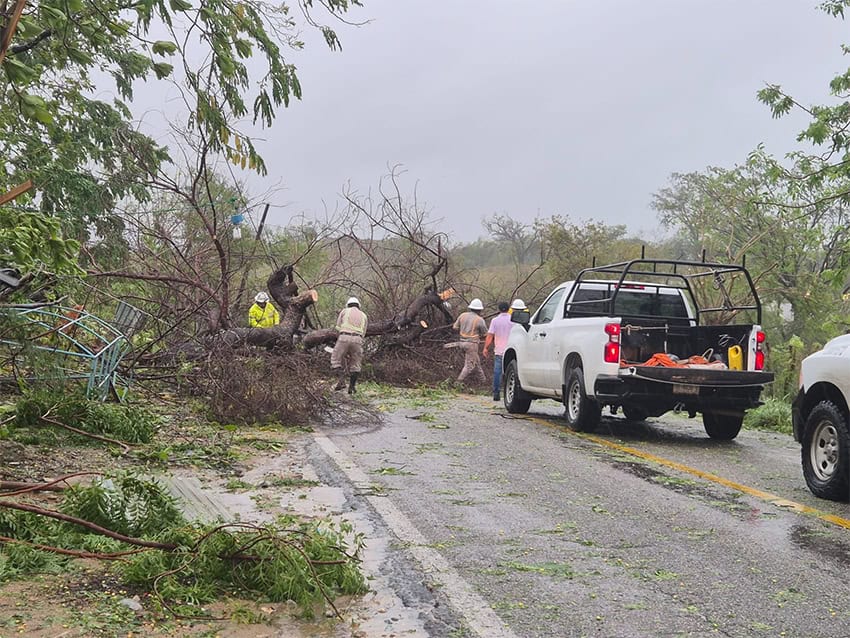
El Universal newspaper reported extensive damage to boats and the principal dock in Puerto Escondido, Oaxaca, about 140 kilometers southwest of Pinotepa Nacional. The new Oaxaca city-Puerto Escondido highway — opened in February 2024 — was closed due to mudslides.

The NHC warned that life-threatening flooding and mudslides are likely, especially in areas of steep terrain. The U.S. National Weather Service has warned that Category 3 hurricanes with this wind strength can cause “devastating damage,” and can lead to power outages lasting several days to weeks.
Storm surge and inland flooding have historically been the leading causes of loss of life during hurricanes, according to the National Oceanic and Atmospheric Administration (NOAA). “Hurricanes can also bring strong winds, tornadoes, rough surf and rip currents,” NOAA warned.
Although Erick is expected to dissipate over the coastal mountains of southwestern Mexico by Thursday night, it will continue to produce heavy rainfall. As of 9 a.m., there were reports of about 250 mm (10 inches) of rain in the mountains west of Oaxaca city, and additional heavy rains were forecast through Thursday night.
Erick is forecast to produce between 8 to 12 inches of rain, with maximum totals of 16 inches across the states of Oaxaca and Guerrero. Trailing Erick, storm surges accompanied by large and destructive waves were expected to produce coastal flooding in areas of onshore winds.
Hurricane-force winds were forecast to decrease further by mid-afternoon in the Hurricane Warning areas. The area from Acapulco east to Puerto Escondido, Oaxaca, remained under a Hurricane Warning, while the area west of Acapulco to Tecpan de Galeana, Guerrero, is under a Tropical Storm Warning.
A Hurricane Warning means that hurricane conditions are expected somewhere within the warning area. A Tropical Storm Warning means that tropical storm conditions are expected somewhere within the warning area.
With reports from El Universal, El Economista, CNN and CBS News