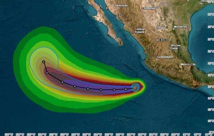
Hurricane Narda will bring heavy rains primarily to the western states of Guerrero, Michoacán and Colima, where authorities have issued alerts due to the storm’s potential severity.
While the hurricane is expected to move parallel to the coast without making landfall, it will bring intense rainfall and strong winds to Mexico’s central Pacific region. Narda is currently a Category 1 hurricane and is expected to continue on a westward path away from mainland Mexico.
According to the National Meteorological Service (SMN), at 9 a.m. on Tuesday, Hurricane Narda was located 475 kilometers southwest of Manzanillo, Colima, and 480 km south-southwest of Playa Pérula, Jalisco, with maximum sustained winds of 140 kilometers per hour, gusts of 170 kilometers per hour, and moving west at 20 kilometers per hour.
The states of Guerrero, Michoacán and Colima, which sit along the Pacific coast, will likely experience very heavy to intense rainfall with expected accumulations ranging between 75 and 150 millimeters within 24 hours.
Strong winds and high waves in coastal areas are also anticipated, which will heighten the risk of landslides, flooding in low-lying areas and rising levels in rivers and streams.
In addition to these states, forecasters have warned that Jalisco will also experience intense rainfall as well as wind gusts of 40 to 60 kilometers per hour. Waves in coastal areas could reach between 2.5 and 3.5 meters in height.
Although with less intensity, Narda will also bring rainfall to the states of Nayarit, México state and Mexico City.
Authorities have urged residents in the affected areas to heed safety recommendations due to the potential for damage caused by the heavy rains.
Narda is the 14th cyclone of the season to form in the Pacific Ocean. The season typically ends by Nov. 30.
With reports from El Financiero and TV Azteca
