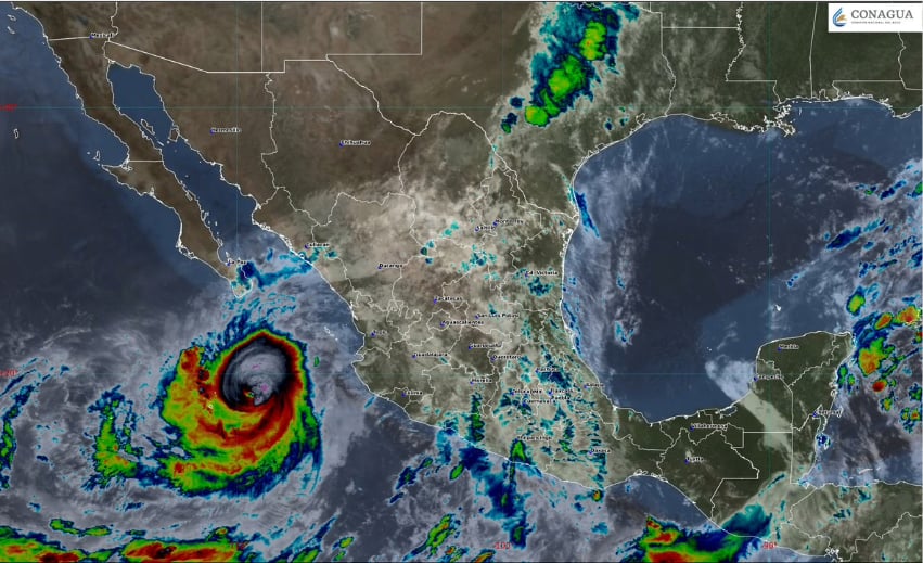
Rachel, hard on the heels of Polo, has become the latest major hurricane in the Pacific. Poised to increase to Category 4 as early as Friday, it is fueling dangerous flood threats along coastal areas.
Rachel — a Category 3 hurricane as of early afternoon Thursday, with maximum sustained winds of 195 km/h (121 mph) and gusts reaching 240 km/h (149 mph) — was about 415 km east-southeast of Cabo Corrientes, Jalisco.
⚠️ ¡Alerta por tiempo severo! Un #FrenteFrío y un #Huracán detonarán lluvias torrenciales del 28 de septiembre al 4 de octubre 🌧️🌀.
José Martín Cortés con el panorama completo en 🔗https://t.co/MtmR1SPTWb pic.twitter.com/YsjTDgj1P8
— Meteored México (@meteoredmx) September 28, 2026
The center of the storm system was 390 kilometers south of Cabo San Lucas, Baja California Sur, and was moving west at 6 km/h. Hurricane-force winds extended outward up to 40 km from Rachel’s center, with tropical-storm-force winds extending outward up to 260 km.
While expected to increase to Category 4 and remain a major hurricane through Saturday, Rachel’s projected northwestern course suggests it will not make landfall in Mexico.

However, the National Meteorological Service (SMN) is forecasting very heavy rainfall for Nayarit, Sinaloa and southern Baja California Sur (up to 75 mm) through Friday, increasing the risk of landslides, cresting rivers and flooding.
The National Civil Protection Coordination is urging local authorities and residents of potentially affected areas to follow updates on Rachel’s development.
State and federal authorities are also on alert in the states of Michoacán, Colima and Jalisco. The Jalisco state government ordered schools closed on Wednesday, but they had reopened on Thursday.
The season’s first cold front has arrived
At the same time, the first cold front of the 2026-2027 season arrived and was poised to cause heavy rains, strong gusts of wind and a drop in temperature in several northern and central states.
According to the SMN, the cold front will move from the northern border towards the northern Gulf of Mexico, its mass of cold air lowering temperatures and stirring up conditions of atmospheric instability.
The SMN forecasts that the most significant effects of the cold front will last three to four days, impacting the following states: Coahuila, Nuevo León, Tamaulipas, San Luis Potosí, Zacatecas, Durango, Chihuahua, Sonora and Aguascalientes.
In addition to the colder temperatures, Coahuila, Nuevo León, Tamaulipas, Durango, Zacatecas and San Luis Potosí could see from 75 to 150 mm of rainfall.
Additionally, these northern and central states could see winds gusting up to 60-70 km/h (37-44 mph) with possible whirlwind formations in northern Coahuila.
With reports from El Informador, The Associated Press and La Crónica