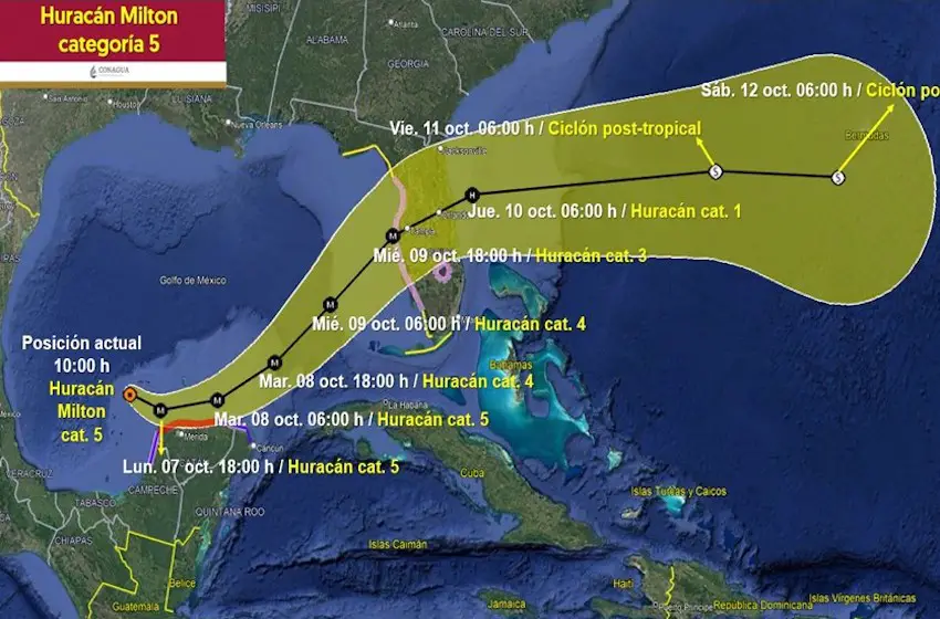
Hurricane Milton rapidly grew into a Category 5 storm on Monday morning as it continued its path northeast across the Gulf of Mexico toward Tampa, Florida.
At 9 a.m. on Monday, the United States National Hurricane Center (NHC) issued an advisory warning residents of the Yucatán Peninsula to expect hurricane-force winds and a life-threatening storm surge across the northern coast. The same advisory warned Florida residents to brace for severe hurricane conditions beginning on Tuesday night.
…MILTON RAPIDLY INTENSIFIES INTO A CATEGORY 5 HURRICANE…
Data from an Air Force Reserve Hurricane Hunter aircraft indicate that Milton has strengthened to a category 5. The max sustained winds are estimated to be 160 mph with higher gusts. https://t.co/dv1LkCViaN pic.twitter.com/zUwi2CNJhi
— National Hurricane Center (@NWSNHC) October 7, 2024
Milton formed as a tropical storm off the coasts of Veracruz and Tabasco in the southwestern Gulf of Mexico on Saturday, intensifying rapidly through the weekend while moving northeast at between 13-15 km/h.

The storm grew into a Category 3 hurricane before dawn on Monday but exploded into a Category 5 storm less than two hours later as it moved parallel to the Yucatán peninsula.
At 11 a.m., Milton was about 200 kilometers west of Progreso with maximum sustained winds of 250 km/h, according to the NHC.
Yucatán Governor Joaquín Díaz Mena ordered all schools closed on Monday and closed all of the state’s ports as well, according to the news agency Aristegui Noticias.
ALERTA NARANJA🟠 para los municipios del centro, norte, noreste, noroeste y oeste #Yucatán.
ALERTA AMARILLA🟡 para los municipios del este y sur de #Yucatán.
Ante la cercanía del Huracán #Milton categoría 4, el Sistema Nacional de #ProtecciónCivil ha establecido alertamientos… pic.twitter.com/IHpAUIacGI
— Joaquín Díaz Mena (@huachodiazmena) October 7, 2024
A hurricane watch is in effect from Río Lagartos to Cabo Catoche, Yucatán, and from the city of Campeche to Celestún, Yucatán.
Torrential rains (150 to 250 millimeters) are forecast for the states of Campeche and Yucatán, while intense rains (75 to 150 mm) are expected in Quintana Roo on the eastern side of the peninsula. Tabasco, Veracruz and Puebla will see rainfall from Milton on Monday, as well.
Wind gusts could reach 180 km/hr and waves of up to seven meters are likely along Yucatán’s northern coast. Residents of “orange” areas of the state are instructed to remain calm, stay in a safe place and disconnect electronics, gas and water lines.
Mexico’s national weather agency (SMN) was also monitoring a new low-pressure system in the Pacific which has a 70% probability of developing into a tropical cyclone by Wednesday. This system is expected to bring heavy rains to the states of Chiapas, Colima, Guerrero, Jalisco, Nayarit, Oaxaca and Michoacán on the Pacific coast.
With reports from El Economista, Aristegui Noticias and AOL.com