

The National Oceanic and Atmospheric Administration (NOAA) has just updated its Sargassum Inundation Risk (SIR) tool to offer daily reports and more detailed tracking of sargassum influxes in the Caribbean, tropical Atlantic, and Gulf of Mexico.
Sargassum is a floating brown marine macroalga that, upon reaching the coast, begins to rot, releasing a foul smell that poses risks to humans and the environment.
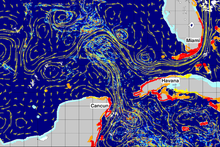
With the latest updates, NOAA is now able to provide daily reports with a resolution of half a mile (one kilometer). Previously, these reports were issued on a weekly basis with a resolution of three miles (five kilometers).
Designed as a risk assessment system, the SIR is intended to optimize sargassum monitoring for public use with special focus on coastal authorities, hotels, tour operators and communities so that they can anticipate and organize cleanup efforts.
“Our updated risk tool is now more timely and the higher resolution offers more detail on where sargassum is and where it is not,” Matthieu Le Henaff, an oceanographer at NOAA’s Atlantic Oceanographic and Meteorological Laboratory who oversees the SIR, said.
The maps generated by this new tool are created by integrating satellite data — which allows for the identification of sargassum in the open ocean — with ocean current models that pinpoint coastal areas with the highest probability of accumulation.
Mexican researchers also use satellite images to monitor sargassum before it reaches the Mexican coasts.

Using images from the Sentinel-2 satellite, scientists at the National Autonomous University of Mexico (UNAM) monitor the region every five days to pinpoint large sargassum blooms at sea. The study area covers the coast of Quintana Roo, in addition to those in Belize, Guatemala and part of Honduras, because currents carry the biomass to those countries first before it reaches Mexico.
To verify that the satellite images match what is happening on the coast, scientists also use floating GPS devices to track the movement of the sargassum blooms; spectroradiometers that identify the characteristic light signature of the sargassum; and drone flights to assess its impact on the reef.
This year, scientists are monitoring a mass of approximately 40 million tonnes of sargassum that is moving west across the Atlantic Ocean. Playa del Carmen has suffered the worst effects so far in 2026, with seaweed influxes set to intensify from May to July.