When Teotihuacán, one of the largest and most powerful pre-Hispanic city-states collapsed around 750 A.D., a number of other city-states were ready to step in and fill the void. One of them was Xochicalco, which may even have had a role in Teotihuacán’s fall.
What’s left of Xochicalco, which was once one of central Mexico’s most important commercial and religious centers, is spread across three hills, about 38 km (25 miles) southeast of Cuernavaca, Morelos.
According to the National Institute of Anthropology and History (INAH), Xochicalco, whose Nahuatl name means “In the Place of the House of Flowers,” was founded between 650 and 700 A.D. by the Olmeca-Xicalancas, Mayan traders from Campeche.
At its peak, it’s estimated that the city covered just over 700 hectares (1,750 acres) and was home to a population of between 15,000 and 20,000. Xochicalco existed for a relatively brief period of time: the city was burned and destroyed around 900 A.D., possibly by an internal uprising.
Xochicalco was built on three levels. The lowest level contains the residences where most of the population lived. This level is surrounded by walls, indicating that the city was built with defense in mind. The next level contains an area called the Market Ensemble, centered around the Plaza of the Stele of the Two Glyphs. This plaza contains two temples, one on the east side and one on the west, with the titular stele standing on a small altar between the two. Evidence suggests that this plaza was the city’s original ceremonial site.
Ancient ancient roads lead from the valley below up to this site, perhaps indicating that, rather than being a place restricted to elites and priests, it was open to residents.
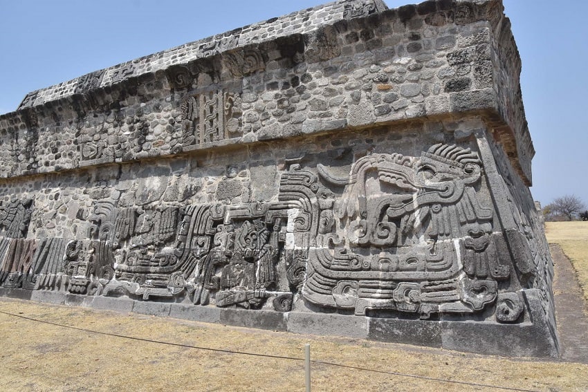
The stele’s two glyphs have been translated as “10 Reed” (although one source translates it as “10 Cane”) and “9 Reptile Eye,” which are dates. There was no information at the site as to what the dates represent, but it’s thought that the stele was erected to honor Quetzalcóatl, one of Mesoamerica’s most important pre-Hispanic gods. The god was so important, in fact, that standing nearby is the impressive Temple of the Feathered Serpent, another name for Quetzalcóatl.

That temple, which may have been dedicated to the warrior caste, is sculpted with eight stylized serpents, two on each side, that are covered with feathers. These carvings were certainly influenced by Teotihuacán, where similar carvings can be found. Shells are also depicted on the temple’s sides, representing water and likely Tlaloc, the god of rain and water.
Among several of the serpents’ undulations are seated figures that are thought to depict Mayans because of their deformed heads – cranial deformation was practiced by Mayan elites. Glyphs representing speech come out of the figures’ mouths, possibly signifying praise.
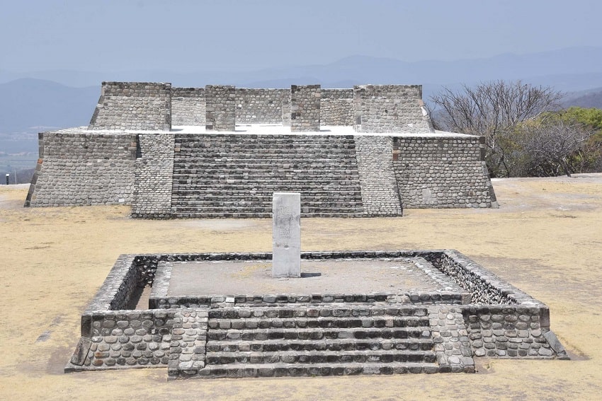
The Great Pyramid, the tallest structure in Xochicalco, is located on the north side of the ruins and was dedicated to Tlaloc. The highest level of the city contains more temples and other buildings – most likely residences for priests and the ruling class – and the Ramp of Animals, which was paved with 271 stone slabs engraved with images of birds, mammals, serpents and insects. Visitors can’t walk on the ramp and it can be a little difficult to see the carvings clearly, but some of the stones can be observed in the site’s museum.
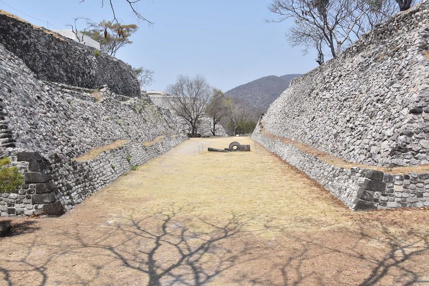
Three ball courts are located in the northern, eastern and southern parts of the ruins. It’s thought that each of these served a different function, although all are believed to have been utilized during religious ceremonies.
One of Xochicalco’s most amazing features is a cave on the west side of the city known as the Cave of the Astronomers. Whether the cave is natural or man-made is unclear, but it was used as an observatory and was almost certainly a place where religious ceremonies were held.
A chimney-like structure called a zenith tube was built into the roof of the cave, allowing observers to track the sun’s movement and the solstices. This tube lets in a beam of light during the sun’s zenith – a time when the sun is directly overhead – each year on May 14 and 15 and again on July 28 and 29 (there are many photographs of this phenomenon online).
Several sources indicate that direct sunlight enters the cave for 105 days (between the April 30 and August 15), leaving 260 days when the cave is in darkness – the Mesoamerican sacred calendar comprised thirteen months of twenty days each, for a total of 260 days. Although most scholars believe this cave was used to track the sun’s movements, at least one researcher has argued for that it served as a lunar observatory.
Unfortunately, the sign pointing to the cave had “Temporarily Closed” stamped on it when we visited.
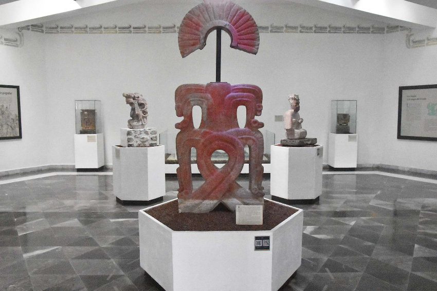
Xochicalco’s museum has six exhibition galleries displaying numerous objects excavated from the ruins. Interestingly, it was the world’s first ecological museum upon its inauguration in 1996: the interior is illuminated by natural light, rainwater is collected in an underground cistern and wastewater is treated and used to water the gardens surrounding the museum.
Xochicalco was named a UNESCO World Heritage Site in 1999 and is definitely worth a visit. Some basics to be aware of: come with a full tank of gas because there are very few gas stations on the highways leading to the ruins. When you arrive, go to the museum to buy your ticket, which is $90 pesos ($5 USD). There are some trees around the ruins but not much shade, so bring a sun hat, sunscreen and lots of water. We went in late March and were surprised at how hot it was; we sucked down a liter of water between us.
Figure on just under two hours to cover the ruins. Bring snacks and maybe lunch. We went to Cuentepec, about 20 minutes away, and only found one stand selling quesadillas. There are many small stands along Route 166 that serve simple fare and at least two restaurants in Alpuyeca, about 30 minutes from the ruins.
Joseph Sorrentino, a writer, photographer and author of the book San Gregorio Atlapulco: Cosmvisiones and of Stinky Island Tales: Some Stories from an Italian-American Childhood, is a regular contributor to Mexico News Daily. More examples of his photographs and links to other articles may be found at www.sorrentinophotography.com He currently lives in Chipilo, Puebla.