

Tanzania has its 90-kilometer-long Mount Kilimanjaro trek and the US has its Pacific Crest Trail, stretching 4270 kilometers from north to south. These and other long trails around the world are laid out so trekkers can walk in safety, avoid getting lost, and find food and water along the way. If they succeed in doing the whole route, they may come away at the end with high satisfaction, a certificate, and, without a doubt, sore feet.
Even though Mexico was crisscrossed with thousands of kilometers of caminos in pre-Hispanic times, today it has no well-established, long-distance-trail network—but that has not stopped the intrepid from setting up their own challenges.
“I want you to meet two extraordinary trekkers,” I was told by Matteo Volpi, owner of Guadalajara’s Volpi Outdoor Gear.
How to get by on very little water
Volpi says he admires Gabriel Román and Lucy Santana because they have laid out some fascinating routes of their own and succeeded in walking them, despite obstacles that might have defeated less determined hikers.
“For example,” he told me, “because Mexico doesn’t have an infrastructure for doing multi-day hikes, there may be no sources of water in the dry season, over huge distances. Well, Gabriel and Lucy decided to solve the problem by training themselves to get by on very little water, until their bodies got used to it.”
Over the last three years, Gabriel and Lucy have carried out three extraordinary treks– one per year – which have grabbed the attention of long-distance hikers in western Mexico.
The Plesiosaurus Route
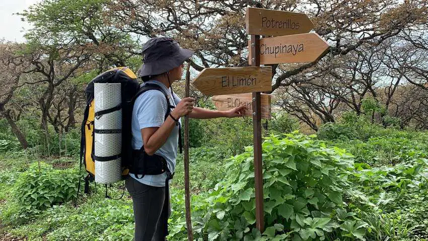
This 71-kilometer walk starts in Jocotepéc at the west end of Lake Chapala and follows the two-kilometer-high ridge above the lake eastward to the extraordinarily beautiful Mesa de Ocote. Here the route does a U-turn, heading back west, up and over nearly three-kilometer-high El Cerro Viejo, terminating in the village of El Molino.

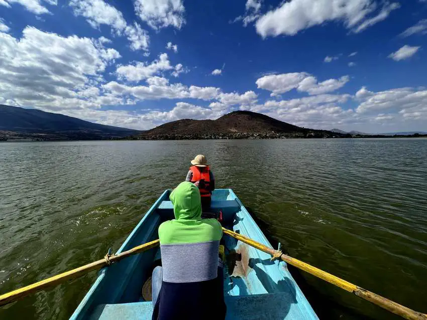
They started out on July 15, 2021, at 4:00 am, catching a bus to Jocotepéc from Guadalajara. Hiking east along the ridge paralleling the shoreline offered views of little villages in the distance and, of course, frequent spectacular views of Lake Chapala.
This is an up-and-down trail of peak after peak, which—after 25 kilometers—brought them to the Mesa del Ocote, a stunningly beautiful forest of tall oaks that somehow looks like it belongs in Canada, not Mexico. “Here, in the very home of the vultures circling above us, we hugged each other and congratulated each other and set up our camp at 2390 meters above sea level,” Gabriel told me.
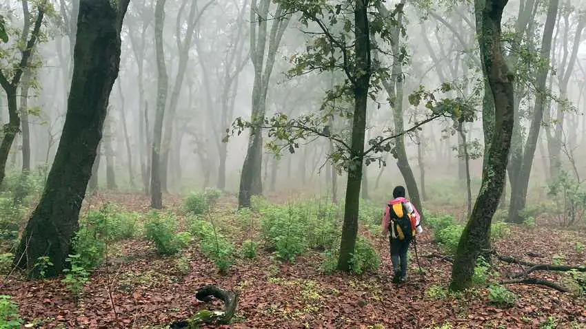
The Enchanted Forest
Heavy rain hit them in the middle of the night, “but,” comments Lucy, “our tent withstood the winds and the downpour, and the next morning we left this gorgeous peak and hiked down into a place known as The Enchanted Forest. Heavy white fog had settled in the valley giving it a sinister look that contrasted dramatically with the cheerful, warm, singing of what seemed like hundreds of birds and the whisper of the wind blowing through the trees. They weren’t kidding when they called this place enchanted—what a breathtaking show!”
From here they started up the long ridge to the peak of Cerro Viejo, enjoying sunshine and a good view of Lake Cajititlán.
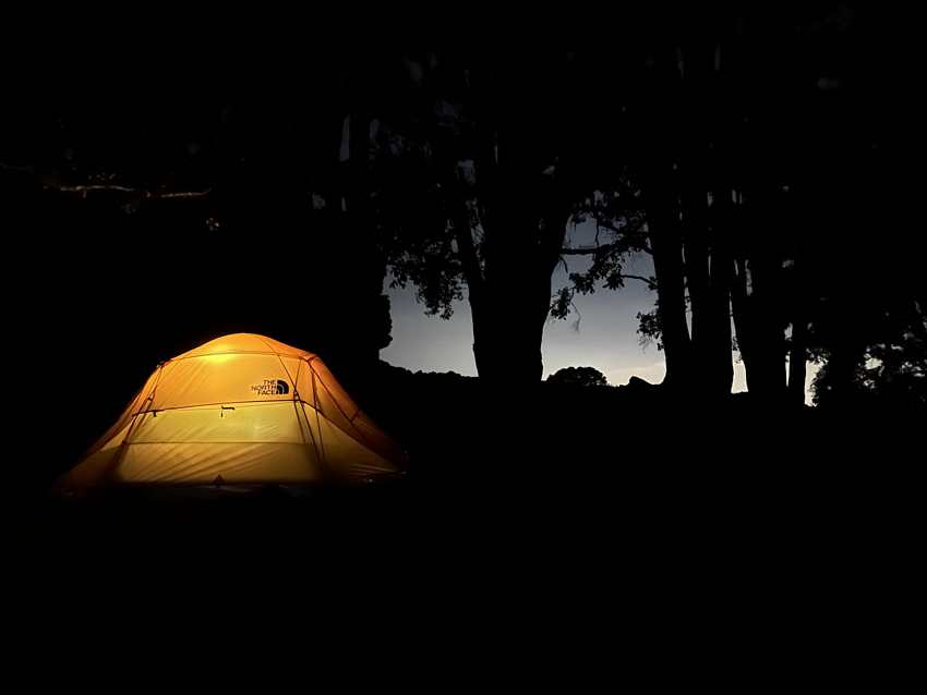
Hot breath in the dead of night
We arrived at 2300 meters above sea level at 8:30 pm,” says Gabriel, “and we looked for a place to set up the second camp.”
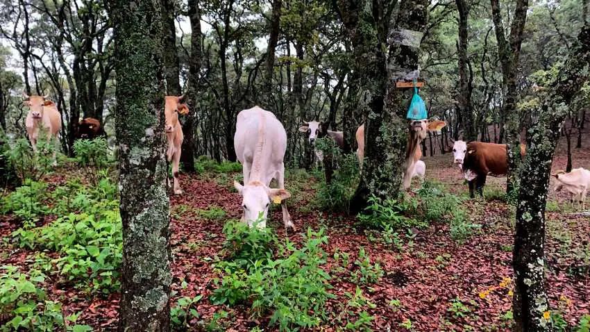
“Fortunately, this night it did not rain hard,” he adds, positively. “However, we were visited by a herd of cows who seemed convinced we were hiding something delicious to eat. Have you ever felt the hot breath of a huge cow, through the thin wall of a tent, just a few centimeters from your face? It’s something you could never forget.”
The next day, fortified by blackberries they found along the way, they reached the summit of Cerro Viejo at 2960 meters above sea level. “Now,” said Lucy, “we knew we had left the most difficult part behind and only had a long descent of 18 kilometers ahead of us.”
Wall of thorns, trail of mud
Murphy’s Law then snapped into action. A storm hit them at 2000 meters elevation, transforming the trail into flowing water and mud.
“The last kilometers of this hike were the strangest that I have had to walk,” continues Lucy. “Tightly lining both sides of the flooded trail there was a wall of thorns mixed with cat’s claw, so there was nothing to grab onto as we placed our feet on either side of what was now more of a river than a path. But at last, we reached El Molino.”

2022: Chapala to Mascuala boat-bike-hike route (150 kilometers of mountains, lakes, and canyons)
A year later, the intrepid couple mapped out a unique “Peak-Puddle-Canyon” route for themselves twice as long as the previous. Starting at El Cerro de Garcia, south of Lake Chapala, they hiked and boated their way north over four of Jalisco’s high peaks, across Lakes Chapala and Cajititlán, and then cycled (on a bicycle built for two) through the city of Guadalajara, subsequently (on foot again) bottoming 500-meter-deep Huentitán Canyon and finishing up atop the other side of the barranca at the town of Mascuala, 150 kilometers from their starting point.
The trek took three and a half days. Their only complaint: “We expected the weather to be warmer…those were three very cold nights.”

2023: Crossing Jalisco East to West… almost
Not to be undone distance-wise, this year the couple decided to do a 202-kilometer bike ride across the state of Jalisco from the border of Michoacán, to the border of Nayarit.
Most of this was on paved highways until they came to the town of Tala where they were able to plug into Jalisco’s Vias Verdes (Green Rails) network. These are caminos of concrete (pink, not green!) which have replaced a now antiquated railway system. Finally they reached the little town of Lagunillas. They were now a mere four kilometers from Nayarit.
Their bicycle built for two got them within less than a kilometer of their goal, but when they tried to conquer that last small distance on foot, they discovered just how mal the maleza can get.

Defeated by tiny needles
“It wasn’t just the huizapoles (burrs), “moaned Gabriel, “and it wasn’t just the uña de gato. We hikers have dealt with them before, but when we tried to push that last little bit, we soon found ourselves covered, head to foot with ajuates [from Nahuatl ahuatl], those almost invisible, tiny needles which the Mexican wilderness keeps in reserve for those who think they are macho trekkers. So, only 190 meters from the Nayarit border, we had to turn around and head back the way we came, without fully reaching our goal.”
Yes, trekking in Mexico is different from trekking in other countries and is unfailingly full of surprises. Congratulations to those brave souls who do it. “Walking, walking, and walking through the wilderness,” Gabriel and Lucy told me: “this is what makes us happy!”

 Mexican")