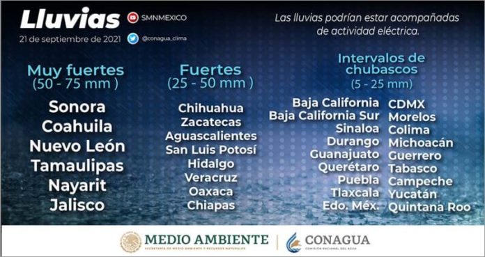
Mexico’s national weather service (Conagua) announced that Mexico’s first cold front of the year has arrived, bringing forecasts of falling temperatures as well as heavy rains, strong winds and even hail in some states, mainly in the north and northeast.
The fronts usually have a duration of between five and seven days.
Cold front season runs from September 15–May 15, generally affecting northern, eastern and southeastern states, and later reaching the center and west of the country. It is most intense in mid-winter from December to February.
Snow recently fell for the first time this year last week on the continent’s northernmost city, Utqiagvik (previously known as Barrow), Alaska, and the spread of arctic ice is in a greater amount than it has been for more than a decade, both signs that wintry conditions have arrived and are heading south.
The cold front, which is interacting with a low-pressure system, according to Conagua, arrived in Chihuahua and Coahuila Tuesday morning and will reach Nuevo León and Tamaulipas Wednesday and northern Veracruz Wednesday night. It is likely to reach the south of the state Thursday.
The front’s movement will bring heavy rains, some hailstorms and winds of 50 kilometers per hour to affected areas. In the north and east, Sonora, Coahuila, Nuevo León and Tamaulipas could see as much as 75 millimeters of rain, according to Conagua, as could Nayarit and Jalisco in the west.
Temperatures are predicted to be lower in the afternoon in the north, northeast, east and center of the country at 20–30 C. Sunrise is likely to record temperatures of 10–19 C, while higher areas of the Altiplano might not exceed 10 C. The first norte, a local wind phenomenon, will arrive for a prolonged spell on the coasts of Tamaulipas, Veracruz and the Isthmus of Tehuantepec with gusts of 60–85 kph.
