Tropical Storm Mario has formed off Mexico’s Pacific coast and is expected to bring wind, rain and possible flash flooding, forecasters said.
Mexico’s National Meteorological Service issued a tropical storm watch for parts of the state of Michoacán, stretching 221 kilometers north from Lázaro Cárdenas to Punta San Telmo. It also warned that gusty winds are possible along the coasts of Guerrero, Michoacan and Colima through tonight.
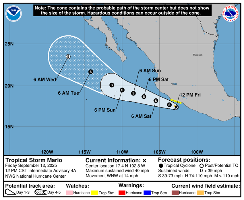
A Friday morning advisory from the U.S. National Hurricane Center (NHC) described Mario as “mini,” but maximum sustained winds were measured at 40 mph (64 kph) with gusts reaching 53 mph (85 kph).
After forming as a tropical depression off the coast of Mexico on Thursday, Mario was upgraded to a tropical storm early Friday.
Mario was centered about 40 miles (64 km) south-southwest of Zihuatanejo, Guerrero, and about 60 miles (97 km) south-southeast of Lázaro Cárdenas at 9 a.m. Friday and was moving west-northwest, roughly parallel to the coastline, at 14 mph.
Mario’s small size and closeness to land initially gave the NHC trouble in projecting its trajectory and strength. Some models showed the system moving inland and dissipating quickly, while others showed Mario reaching hurricane strength.
The latest forecast indicates the center of Mario will remain offshore, according to global weather intelligence company Accuweather, but outer bands could bring heavy rainfall capable of triggering mudslides.

The NHC forecast rainfall totals of 2 to 4 inches (50 to 100 mm), with amounts up to 6 inches (150 mm) in some areas. It also warned of flash flooding across parts of southern Mexico through Sunday.
Mexico’s National Water Commission (Conagua) forecast very heavy rains (50 to 75 mm) in Jalisco, Colima, Michoacán and Guerrero, as well as wind gusts of 50 to 70 km/h. Conagua also warned that waves could reach heights of 2.5 to 3.5 meters along the coasts of Colima, Michoacá, and Guerrero, extending toward the coast of Jalisco through Friday.
The NHC advised interests in these areas to continue monitoring Mario’s progress.
Slower movement toward the west-northwest is forecast through the weekend and Mario is expected to begin moving farther away from the coast on Saturday.
The storm is expected to reach colder waters by day five and become a post-tropical cyclone.
With reports from The Associated Press, Accuweather and UPI