")
As part of an exploration into Mexico’s long and rich history, Mexico News Daily has teamed up with one of the country’s top Maya experts to examine the ancient world that flourished across Mesoamerica. Follow the links to read Part 1, Part 2, Part 3, Part 4, Part 5 and Part 6.
As a professor of Mayan history and an archaeologist, people often ask me where in the Yucatán I would recommend visiting the most. My answer is always Calakmul. The ancient Maya city still exists, although it’s now in the state of Campeche. Situated within Calakmul Biosphere Reserve, its ruins have become a UNESCO site that’s well worth visiting, not just because of the archaeological attractions but also because of the area’s incredible biodiversity.
From discovery to obscurity
Calakmul was discovered in 1931 by botanist Cyrus Lundell, then working for the Mexican Exploitation of Chicle Company. Actually, it was his workers who were extracting resin from sapodilla trees to make chewing gum who discovered the ruins hidden beneath jungle vegetation. But Lundell got the credit.
The presence of two large ancient structures over 40 meters high convinced Lundell to “baptize” the city as Calakmul, which means “two adjacent mounds” in Mayan. Lundell then explored Structure III (often called Lundell Palace), produced the first drawings and maps of the city, and alerted the Carnegie Institution of Washington of what he had found.
The Carnegie was then the most important institution dedicated to Maya area studies, and it soon dispatched renowned archaeologist Sylvanus Morley on an expedition in April 1932, accompanied by distinguished specialists such as Karl Ruppert.
Calakmul aroused great academic curiosity at the time due to the identification of 103 large stone pillars bearing hieroglyphic texts. Both Morley’s expedition and the one organized shortly thereafter — led by researchers Karl Ruppert and John Denison — focused on these monuments. But despite their efforts, Calakmul fell into academic obscurity until the 1980s.

The rediscovery
William Folan of the Autonomous University of Campeche began work at the site after its rediscovery, with his work continued in the 1990s by Mexico’s National Institute of Anthropology and History (INAH), led by archaeologist Ramón Carrasco. It was during these more recent explorations that major archaeological discoveries took place, revealing the true importance of this ancient Maya city.
Today, thanks to the archaeological work carried out at the site, Calakmul stands out as one of the most important Maya cities. Occupied over a long timespan — from the Preclassic through the Postclassic periods — Calakmul was the dynastic capital of some of the most important ruling houses of the Classic period, including the dynasty bearing the Serpent Head Emblem Glyph: the Kanu’l.
Also, advances in hieroglyphic records have made it possible to determine that the ancient name of the city was actually Uxte’tuun, meaning “the place of the 3 stones,” and to identify the names of different architectural areas, such as Chiku Nahb, where part of the local elite likely lived.
The Serpent Head Emblem Glyph: The Kanu’l Dynasty
Calakmul became the capital of the Kanu’l dynasty at the beginning of the AD 7th century, when ruler Yuhkno’m Ch’e’n II — bearer of the Serpent Head Emblem Glyph — established himself in the city. With his arrival, Calakmul experienced significant population growth and urban expansion, weaving a network of alliances with other political entities that ultimately led to a confrontation with its great rival, Tikal, for control of key trade routes.
For nearly 100 years, the Kanu’l of Calakmul dominated the Lowlands and prevailed over Tikal, until the death of Yuhkno’m Yihch’aak K’ahk’ — or “Fiery Claw” — after which circumstances took a turn for the worse and Tikal inflicted severe defeats on the Kanu’l, triggering their dynastic decline.
Getting there
The nearest airport to Calakmul is Chetumal International Airport, about 90 kilometers distant, and there is a Maya Train stop at Calakmul. That said, you’ll still have to drive or arrange transportation to reach the ruins. From the town of Campeche, drive to Conhuas via Federal Highway 186, which runs from Escárcega to Chetumal, then take the turnoff at Conhuas toward the Calakmul archaeological zone. However, be aware that this involves an adventurous 60-kilometer drive through dense jungle along a narrow road where extreme caution is required due to numerous wildlife in the Biosphere Reserve.
Three fees must be paid along the way: one to the National Commission of Natural Protected Areas (CONANP), one to the local ejidal community, and the final at the entrance fee to the archaeological site, which is charged by INAH The site is open from 8 a.m. to 5 p.m.
The Northern Area: Chiku Nahb
The sector known as Chiku Nahb stands out, as it is where some of the most beautiful painted murals in the Maya world were found — depicting scenes of everyday life among different social groups in what may have been a marketplace. Unfortunately, however, this area is not available to visit.
The Grand Plaza
So continue to the Grand Plaza, the city’s political and administrative center, where the most important monuments and tallest structures are found. The most notable Structure VII — one of the tallest buildings in the city and still climbable — which offers a panoramic view of the entire area and an amazing frontal view of Calakmul’s great pyramid.
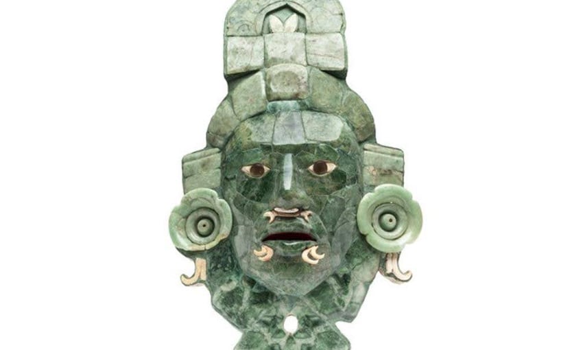
It was within Structure VII that the famous Calakmul jade mask was found, along with its large ceramic relics. Now housed in the Baluarte de la Soledad Museum in the city of Campeche, the jade mask likely belonged to one of the Kanu’l dynasty rulers of the AD 8th century.
Structure II: The Great Pyramid
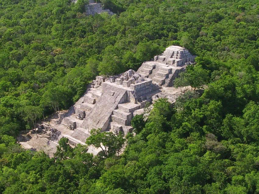
To the south of the Grand Plaza stands Structure II of Calakmul — the great pyramid, which rises over 50 meters high and which can still be climbed. This is highly recommended, as you can see above the jungle canopy all the way to Guatemala. With seven distinct construction phases, the pyramid served as the principal structure of the site, and contains within friezes and modeled, painted masks. It’s considered a “sacred mountain,” where ancestors and principal deities reside.
Within its walls, archaeologists discovered funerary chambers with jade grave goods and human remains belonging — in the case of Tomb 4 — to Yuhkno’m Yihch’aak K’ahk’, or “Fiery Claw,” one of the Kanu’l dynasty rulers who died at the end of the AD 7th century.
Structure I
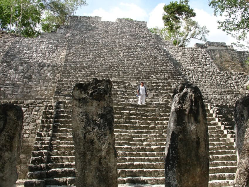
To the southwest stands another notable structure with a highly original name: Structure I. It’s also pyramid-like and worth climbing, despite its 40-meter height. In front of Structure I’s central stairway stand a series of stelae and altars — silent witnesses to the damage caused by looting, with only partial fragments remaining of the monuments that were cut and removed from Calakmul in modern times.
Lundell Palace
To the west, outside the Grand Plaza space, sits Lundell Palace — Structure III of Calakmul — where the botanist resided during his time at the archaeological site and where you can find the graffiti he left for posterity.
In this building, you will observe the large number of vaulted rooms that make up the construction, the reason it was chosen as a residence both in pre-Hispanic times and by Lundell. In addition, one of the city’s most important tombs was found here: the burial of an individual from the Early Classic period, accompanied by a large ceramic assemblage and jade objects.
The Grand Acropolis
After leaving behind the majesty of the Grand Plaza, head to the Grand Acropolis. This area represented the most valuable part of the city — where part of the site’s elite likely resided — and as such, its architecture is more enclosed, with a notable number of rooms featuring interior benches where these important people rested. These spaces were organized around small courtyards where the daily activities of elites took place.
This area also contains Calakmul’s Ball Court, where ritual and political activities were carried out among the sacred lords of different cities.
Practical Tips
It is essential to bring water and food, as there are no vendors inside the site. Given the extent of the zone, the humidity and the physical effort required to climb the structures, fatigue can be a factor. Shaded parking, for example, is available, but it is more than 2.4 kilometers from the archaeological sites. The nearest hotels are more than an hour’s drive away.
Please also remember to respect the local flora and fauna, as you are within a biosphere reserve. Lucky visitors may spot howler monkeys, ocellated turkeys, toucans, peccaries and more.
Pablo Mumary holds a doctorate in Mesoamerican studies from UNAM and currently works at the Center for Maya Studies at IIFL-UNAM as a full-time associate researcher. He specializes in the study of the lordships of the Maya Lowlands of the Classic period.