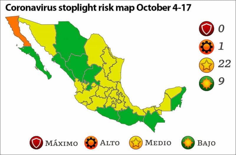
Medium risk yellow is the dominant color on the federal government’s new coronavirus stoplight map, which took effect Monday.
There are 22 yellow states, nine low risk green states and just one high risk orange one – Baja California.
The biggest changes on the current map compared to that in effect for the past two weeks are the increase in the number of green states from four to nine and the decrease in the number of orange states from four to one. The number of yellow states declined from 24 to 22, while the number of maximum risk red states remains at zero.
The map reflects the improved coronavirus situation in Mexico after the third wave of the pandemic peaked in August. Reported case numbers declined 38% in September compared to August, although deaths decreased by just 1.3%.
Yellow states are:
- Aguascalientes
- Campeche
- Coahuila
- Colima
- Guanajuato
- Hidalgo
- Jalisco
- Mexico City
- México state
- Michoacán
- Morelos
- Nayarit
- Nuevo León
- Puebla
- Querétaro
- San Luis Potosí
- Sonora
- Tabasco
- Tamaulipas
- Tlaxcala
- Veracruz
- Yucatán
Painted green on the new map are:
- Baja California Sur
- Chiapas
- Chihuahua
- Durango
- Guerrero
- Oaxaca
- Quintana Roo
- Sinaloa
- Zacatecas
Meanwhile, the Health Ministry reported 2,282 new confirmed coronavirus cases on Monday and 301 additional COVID-19 deaths.

Mexico’s accumulated case tally stands at 3.68 million while the official death toll is 279,104. There are 46,748 estimated active cases, a 25% decline compared to Friday.
Tabasco has the highest number of active cases on a per capita basis with about 130 per 100,000 people. Mexico City ranks second followed by Colima, Yucatán and Guanajuato.
More than 102.6 million vaccine doses have been administered, according to the most recent data. The Health Ministry said Sunday that 72% of the adult population has had at least one shot.
Mexico News Daily