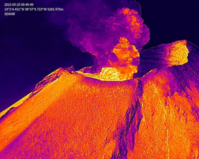
Drone video footage acquired by the Mexican navy on Thursday shows the first close-up images of the smoking Popocatépetl crater following two weeks of increased volcanic activity.
Ten specialists from the navy and National Civil Protection Coordination (CNPC) climbed the slopes of El Popo — as the volcano is commonly known — to capture drone images of the crater that would allow them to monitor the volcanic activity and its evolution.
El Comité Científico Asesor del Volcán #Popocatépetl, después de analizar los videos e imagen obtenidos el día de ayer tras el sobrevuelo del dron de @SEMAR_mx, hace de conocimiento que:
🔹No se observó la presencia de un domo de lava@laualzua
1/4 pic.twitter.com/6xBqfVkv3m— Coordinación Nacional de Protección Civil (@CNPC_MX) May 26, 2023
Drone footage has given authorities a much closer view of activity at the Popocatépetl volcano, which has seen increased activity in recent weeks. (National Civil Protection/Twitter)
The footage can be seen on the CNPC’s Twitter account.
The CNPC reported that the volcanic alert level remains at yellow Phase 3, one step before the red “alarm” stage. Ashfall from the volcano has led to flight cancellations in Mexico City and school closures in Puebla, Mexico state and Tlaxcala. Authorities have prepared for emergency evacuations.
The CNPC’s latest report indicates that the volcano continues to present a tremor signal with decreasing amplitude,” Puebla Governor Sergio Salomón Céspeded said, adding that the upper part of the volcano is not visible.
In the last 24 hours, the volcano has seen 1,089 minutes of high-frequency but low-to-moderate amplitude tremors associated with the continuous emission of gas, water vapor and ash, authorities said.
With reports from Milenio
